| JOURNAL | SUMMARY ???? miles ?? days |
CHASE VAN | TOOLS |
Author: Lisa Beal
Amateur Astronaut Checklist – 2015 edition
Every year my gadget collection evolves, as gear wears out or needs a technology refresh to keep up with new capabilities in the field. The following checklist (and its predecessors) have been my constant companion for over 10 years:
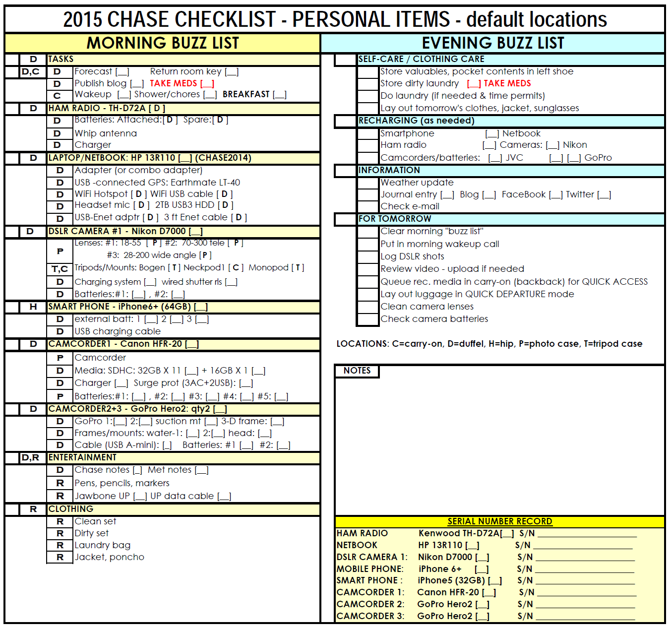
Without the list, I’d be rushing off on certain mornings, only to return to the motel where I’d left a key piece of gear.
I learned the lesson years ago when a member of the tour staff left an expensive camera in Norfolk, Nebraska. We returned several days later to collect the missing camera, but only after frantic phone calls and changes to our positioning strategy to allow the return. While the camera had been turned over to the local police department, it could have just have easily disappeared. After witnessing the anguish suffered by my chase companion, I decided not to repeat his experience. Thus, the list was born.
2015: the season begins
I’m in my final preparations for my annual pilgrimage to Tornado Alley.
More details coming OK.
2015 Season Summary
| CHASE 2015 |
SEASON SUMMARY |
||||||
SEMINARS & TRAINING (WEATHER/SAFETY): |
20+ hours of classroom training on weather (especially radar interpretation), first aid, and CPR [163 miles travel] |
||||||
| DATE | DAY | START | END | MI. | REMARKS | ||
| 13FEB2015 to 15FEB2015 |
Fri. Sat. Sun. |
Bolingbrook | IL | Denver | IL | __ | ChaserCon 2015 |
| 04MAR2015 | Sat. | Bolingbrook | IL | Plainfield | IL | __ | Basic Spotter Training (2 hr.) |
| 14MAR2015 | Sat. | Bolingbrook | IL | Naperville | IL | 20 | DuPage OHSEM Advanced Spotter Training (8 hr.) https://www.dupageco.org/weatherseminar/ |
| 18MAR2015 01APR2015 15APR2015 |
Wed. | Bolingbrook | IL | Naperville | IL | 20 | Naperville EMA Radar classes (6 hr.) |
| 28MAR2015 | Sat. | Bolingbrook | IL | Batavia | IL | 43 | 35th Annual FermiLab/Skilling Severe Weather Seminar (6 hr.) |
| FUTURE | Mon. | Bolingbrook | IL | Naperville | IL | 20 | Naperville EMA: First Aid, CPR, AED, Blood-borne Pathogens classes |
| DATE | DAY | START | END | MI. | REMARKS | ||
| 06MAY2015 | Wed. | Bolingbrook | IL | PROLOGUE 1 | |||
| 07MAY2015 | Thu. | Bolingbrook | IL | PROLOGUE 2 | |||
| 08MAY2015 | Mon. | Bolingbrook | IL | PROLOGUE3 | |||
| 09MAY2015 | Sat. | Bolingbrook | IL | Oklahoma City | OK | __ | TRAVEL: Flight + __ miles around OKC |
| 10MAY2015 | Sun. | Oklahoma City | OK | Oklahoma City | OK | __ | TRAVEL: __ miles around OKC |
| 11MAY2015 | Mon. | Oklahoma City | OK | UNKNOWN | ?? | ____ | DAY 1: _ |
| 12MAY2015 | Tue. | UNKNOWN | ?? | UNKNOWN | ?? | ____ | DAY 2: _ |
| 13MAY2015 | Wed. | UNKNOWN | ?? | UNKNOWN | ?? | ____ | DAY 3: _ |
| 14MAY2015 | Thu. | UNKNOWN | ?? | UNKNOWN | ?? | ____ | DAY 4: _ |
| 15MAY2015 | Fri. | UNKNOWN | ?? | UNKNOWN | ?? | ____ | DAY 5: _ |
| 16MAY2015 | Sat. | UNKNOWN | ?? | UNKNOWN | ?? | ____ | DAY 6: _ |
| 17MAY2015 | Sun. | UNKNOWN | ?? | UNKNOWN | ?? | ____ | DAY 7: _ |
| 18MAY2015 | Mon. | UNKNOWN | ?? | UNKNOWN | ?? | ____ | DAY 8: _ |
| 19MAY2015 | Tue. | UNKNOWN | ?? | UNKNOWN | ?? | ____ | DAY 9: _ |
| 20MAY2015 | Wed. | UNKNOWN | ?? | UNKNOWN | ?? | ____ | DAY 10: _ |
| 21MAY2015 | Thu. | UNKNOWN | TX | UNKNOWN | ?? | ____ | DAY 11: _ |
| 22MAY2015 | Fri. | Oklahoma City | OK | Bolingbrook | IL | ____ | DAY 12: Departure |
| 23MAY2015 | Sat. | Bolingbrook | IL | Bolingbrook | IL | ____ | Epilogue 1 |
| 24MAY2015 | Sun. | Bolingbrook | IL | Bolingbrook | IL | ____ | Epilogue 1 |
| 25MAY2015 | Mon. | Bolingbrook | IL | Bolingbrook | IL | ____ | Epilogue 1 |
| DATE | DAY | START | END | MI. | REMARKS | ||
| 09APR2015 | Wed. | Bolingbrook | IL | Naperville | IL | Rochelle-Fairdale (EF4) tornado Participated in EOC and field operations |
|
COLOR CODE |
||||||
| Plan was to not chase | GRAY | |||||
| Planned Chase Day (future) | YELLOW | |||||
| Available to chase; no weather (“blue-skied”) | BLUE | |||||
| Chase Day (available and expect stormy weather) | GREEN | |||||
| Weather Stormy, but not available for chasing | PINK | |||||
| BUST DAY – no severe storms where we looked! | ORANGE | |||||
| Training Day | WHITE | |||||
| JOURNAL | SUMMARY ???? miles ?? days |
CHASE VAN | TOOLS |
CHASE2014: Season Plan/Summary
Here is the overall plan for my 2014 storm season (which I’ll update as events warrant):
| CHASE 2014 | DAILY JOURNAL |
DATEDAYSTARTENDMILESREMARKSSEMINARS/CLASSROOM TRAINING: 14 FebruaryFridayBolingbrookILDenverCO-![]() ChaserCon 2014 – day 1 (convention)
ChaserCon 2014 – day 1 (convention)
http://www.chasercon.com/15 FebruarySaturdayDenverCO—![]() ChaserCon 2014 – day 2 (convention)
ChaserCon 2014 – day 2 (convention)
http://www.chasercon.com/16 FebruarySundayDenverCOBolingbrookIL-![]() ChaserCon 2014 – day 3 (convention)
ChaserCon 2014 – day 3 (convention)
http://www.chasercon.com/11 MarchTuesdayBolingbrookILNapervilleIL-![]() Naperville EMA
Naperville EMA
Radar class (#1 of 3)
Weather Command Class I
http://www.napervilleema.org12 MarchWednesdayBolingbrookILNapervilleIL-![]() NEMA Spotter Training (mandatory)
NEMA Spotter Training (mandatory)
http://www.napervilleema.org15 MarchSaturdayBolingbrookILWheatonIL-![]() DuPage OHSEM Advanced
DuPage OHSEM Advanced
Spotter Training (seminar)
http://www.dupagesevereweather.com26 MarchWednesdayBolingbrookILNapervilleIL-![]() Naperville EMA
Naperville EMA
Radar class (#2 of 3)
Weather Command Class II
http://www.napervilleema.org09 AprilWednesdayBolingbrookILNapervilleIL-![]() Naperville EMA
Naperville EMA
Radar class (#3 of 3)
Weather Command Class III
http://www.napervilleema.orgTBAPOSTPONEDBolingbrookILNapervilleIL-![]() Blood-borne Pathogens (mandatory)
Blood-borne Pathogens (mandatory)
http://www.napervilleema.orgSOUTHERN/GREAT PLAINS CHASES: mid-May: 4060 miles / 11 days
![]()
09 MaySaturdayBolingbrookIL––Prologue10 MaySaturdayBolingbrookILOklahoma CityOK–TRAVEL11 MaySundayOklahoma CityOK—PLAYING TOURIST12 MayMondayOklahoma CityOK______DAY 1: ORIENTATION; DEPART BASE13 MayTuesday_________DAY 2: _14 MayWednesday_________DAY 3: _15 MayThursday_________DAY 4: _16 MayFriday_________DAY 5: _17 MaySaturday_________DAY 6: _18 MaySunday_________DAY 7: _19 MayMonday_________DAY 8: _20 MayTuesday_________DAY 9: _21 MayWednesday_________DAY 10: _22 MayThursday_________DAY 11: RETURN TO BASE23 MayFridayOklahoma CityOKBolingbrookIL___Homeward bound24 MaySaturdayBolingbrookIL EpilogueIL/IA CHASES/SPOTTING: Chaser/spotter fun within 300 miles of home
(TBA)(TBA)BolingbrookIL(TBA)– VIRTUAL CHASES/SPOTTING: Like chasing without leaving home (or the office)
(TBA)(TBA)BolingbrookIL(TBA)–
| Plan was to not chase | GRAY |
| Planned Chase Day (future) | YELLOW |
| Available to chase; no weather (“blue-skied”) | BLUE |
| Chase Day (available and expect stormy weather) | GREEN |
| Weather Stormy, but not available for chasing | RED |
| BUST DAY – no severe storms where we looked! |
ORANGE |
| Training Day |
WHITE |
| Accommodations | Restaurants | Tools | Web Links |
NOTE: The restaurant and accommodations links will be dead until I get out in the field.
MIGRATION STATION
We’re in the process of migrating to GoDaddy from Yahoo.
KNOWN ISSUES:
- Blog text is here, but images will need to be re-imported. 🙁
- My original theme is lost AND unavailable in the current theme gallery. I’m looking for a replacement.
- L:OTS of formatting issues (mostly due to #2). Working to fix it. Auuuuuugh! 😮
Thanks!
22 May 2014 – [DRAFT]
0730MDT – wake; blog; pack
0845 – breakfast: scrambled eggs to-order
1000 – Depart Stratton, CO. I’ve missed the briefing (or vice versa). We are heading to the TX/NM border area,
where we expect to encounter a wind/hail event. Gustnadoes or a brief spin-up tornado are possible.
After the rain-wrapped tornado(es) near Denver, we are still a little vortex-hungry.
1132MDT – MD655 issued: NE/E NM, severe hail/wind event, evolving to MCS (http://www.spc.noaa.gov/products/md/md0655.html)
1206 – Arrive at Lamar, CO; we grad a quick Burger King lunch. I actually am one of the first to the counter, so I get to sit and eat for a change. I grab a large cup of ice with a bit of water added. I’ll use this to re-stock my Monster beverage canteen as we go. This canteen is still going strong after 3 days, unlike its predecessors that were dented and crushed by the change in atmospheric pressure as we descended from the mountains.
1207MDT – MD656 issued for SE WY, NE/central CO: wind/hail threat (http://www.spc.noaa.gov/products/md/md0656.html)
1348MDT – Pass through Campo, CO (“You’re welcome, Eric!”)
____ – MD658 issued for TX panhandle and western OK: http://www.spc.noaa.gov/products/md/md0658.html
____ – MD663 issued: http://www.spc.noaa.gov/products/md/md0663.html
1356MDT/1456CDT – enter OK, Central time
____ – We cross into Texas (our 8th state of the trip) from the north, bypassing New Mexico for the moment. [We never get there, actually.]
1556CDT – Conlen, TX (home of “Tall Tex” statue; http://www.agilitynut.com/11/4/conlen4.jpg , http://www.roadsideamerica.com/story/11608)

____ – We take a backroads (FM (farm) roads), some paved, some gravel, some plain dirt. Yee-haw!
____ – We spot dusty storm outflow in the distance, We are entering the storm boundary, where we have some chance
to see brief gustnadoes or tornadoes. We blast south a ways.
____ – We flee the blowing dust, moving east then south for a better view.
____ – Bill sees a suspicious cloud on our 9-o’clock, so he stops us for a look. Possible weak tornado is pulling
dirt up from the ground. We spot a funnel above, but the dust makes photography difficult. Tough to focus
me and my camera as I chew on the dust that these Texas winds are forcing into my teeth.
____ – As we retreat, the roads are almost totally obscured. Our drivers do an excellent job keeping from from
driving into a field (or each other). Visibility is only a couple hundred feet, as best.
____ – We give up on the storms, as they are just blowing dust around and the prospects of a tornado are gone now.
We head for Shamrock, TX, where Bill has booked our rooms for the night.
____ – Arrive at Shamrock; we check into our rooms; 15 minutes later, we do a convenience store run a few blocks away. The C-store at US-83 and I-40 (the replacement for he epic US-66) has TONS of great souvenirs; Marina and Owen complete their refrigerator magnet collection of the 8 states we’ve visited: Oklahoma, Missouri, Kansas, Nebraska, Wyoming, South Dakota, Colorado, and Texas (in order). We return to the motel for an impromptu party to celebrate our journey, recollect stories, and appreciate one another’s company one last evening.
0020 – Lights out!
[MORE INFO, DISORGANIZED, BELOW]
May 22, 2014 1630 UTC Day 1 Convective Outlook
Updated: Thu May 22 16:12:40 UTC 2014 (Print Version | | )
Probabilistic to Categorical Outlook Conversion Table
Categorical
Tornado
Wind
Hail
Population
Cities/Towns
CWAs
Interstates Counties
ARTCC FEMA Regions
Categorical Day1 1630Z Outlook
Risk Area (sq. mi.) Area Pop. Some Larger Population Centers in Risk Area
SLIGHT 259,763 43,926,981 New York, NY…Philadelphia, PA…Denver, CO…Baltimore, MD…Nashville, TN…
Forecast Discussion
SPC AC 221609
DAY 1 CONVECTIVE OUTLOOK
NWS STORM PREDICTION CENTER NORMAN OK
1109 AM CDT THU MAY 22 2014
VALID 221630Z – 231200Z
…THERE IS A SLGT RISK OF SVR TSTMS FROM NY SOUTHWARD INTO VA…
…THERE IS A SLGT RISK OF SVR TSTMS ACROSS PARTS OF THE TN
VALLEY…
…THERE IS A SLGT RISK OF SVR TSTMS ALONG THE FRONT RANGE OF WY/CO
SOUTHWARD INTO EASTERN NM/WEST TX…
…SUMMARY…
AREAS FROM THE CENTRAL APPALACHIANS WESTWARD TO THE MIDDLE
MISSISSIPPI VALLEY WILL EXPERIENCE NUMEROUS STRONG TO SEVERE STORMS
WITH DAMAGING WINDS AND HAIL TODAY. STRONG TO SEVERE THUNDERSTORMS
WITH ISOLATED DAMAGING WINDS AND HAIL SHOULD DEVELOP ACROSS PARTS OF
THE NORTHEAST AND MID-ATLANTIC.
STORMS WILL ERUPT ALONG THE FRONT RANGE OF THE ROCKY MOUNTAINS FROM
SOUTHEAST WYOMING TO COLORADO…AND ADJACENT AREAS OF THE SOUTHERN
AND CENTRAL HIGH PLAINS. SOME OF THESE STORMS WILL PRODUCE STRONG
WINDS AND HAIL.
…NY TO VA…
CYCLONIC NORTHWEST FLOW ALOFT IS PRESENT TODAY OVER THE GREAT LAKES
AND NORTHEAST STATES TODAY. VISIBLE SATELLITE IMAGERY SUGGESTS
RELATIVELY STRONG HEATING AND DESTABILIZATION WILL OCCUR THIS
AFTERNOON FROM EASTERN NY INTO THE MID ATLANTIC REGION. THIS
CORRIDOR IS EXPECTED TO SEE SCATTERED THUNDERSTORM DEVELOPMENT.
SUFFICIENT DEEP LAYER SHEAR WILL PROMOTE A FEW STRONG/SEVERE STORMS
CAPABLE OF HAIL AND DAMAGING WINDS. REFER TO MESOSCALE DISCUSSION
653 FOR FURTHER DETAILS.
…TN VALLEY…
FULL SUNSHINE IS OCCURRING ACROSS PARTS OF KY/TN TODAY…WHERE
DEWPOINTS IN THE 60S WILL YIELD AFTERNOON MLCAPE VALUES OVER 2500
J/KG. WHILE ISOLATED TO WIDELY SCATTERED THUNDERSTORM DEVELOPMENT
IS EXPECTED…WEAK FORCING AND SUBTLE UPPER RIDGING SUGGEST THAT
COVERAGE WILL BE LIMITED. THOSE STORMS THAT FORM WILL POSE A RISK
OF LARGE HAIL AND DAMAGING WINDS. HAVE BACKED OFF ON HIGHER
PROBABILITIES OVER THIS AREA DUE TO CONCERNS REGARDING COVERAGE.
…WY/CO…
ISOLATED THUNDERSTORM DEVELOPMENT APPEARS LIKELY AGAIN TODAY ALONG
THE FRONT RANGE OF SOUTHEAST WY INTO CO. THE DCVZ WILL BE ACTIVE
AGAIN THIS AFTERNOON…FOCUSING A RISK OF SUPERCELL STORMS NEAR THE
DENVER AREA. STORM-SCALE MODELS SUGGEST CONVECTION OVER SOUTHEAST
CO MAY BE MORE WIDESPREAD TODAY…POSING A RISK OF LOCALLY GUSTY
WINDS AND HAIL.
…ERN NM/WEST TX…
THUNDERSTORMS ARE EXPECTED TO FORM ONCE AGAIN ALONG AND EAST OF THE
DRYLINE OVER EASTERN NM AND WEST TX. MULTICELL STORMS CAPABLE OF
DAMAGING WINDS AND HAIL WILL ONCE AGAIN BE A RISK.
..HART/SMITH.. 05/22/2014
CLICK TO GET WUUS01 PTSDY1 PRODUCT
NOTE: THE NEXT DAY 1 OUTLOOK IS SCHEDULED BY 2000Z
CURRENT UTC TIME: 1654Z (10:54AM), RELOAD THIS PAGE TO UPDATE THE TIME
Satellite image(s) [ABQ, vis]
generated from http://weather.rap.ucar.edu/satellite/ at Thu, 22 May 2014 16:58:54 GMT
NEXRAD radar image(s) [KPUX BREF1]
generated from http://weather.rap.ucar.edu/radar/ at Thu, 22 May 2014 17:00:12 GMT
Click image below for corresponding velocity image
If the image below is out of date try the latest image from the National Weather Service instead.
—
—
—
—
—
—
____ – ____
____ – ____
____ – ____
____ – ____
____ – ____
____ – ____
____ – ____
____ – ____
EOD – _____
| Start | _ |
| Finish | _ |
| Route | _ |
| Miles | ___ |
21 May 2014 – The Denver Monster [PARTIAL]
More details to be added later. Below are some photos to hold you over.
0715MDT: wake; pack battery charger
0845: breakfast
1000: briefing. Target: Denver to Ft Morgan/Sterling
1209: MD636 issued: Supercell tornado risk with 1-2 storms! (http://www.spc.noaa.gov/products/md/md0636.html)
1215-1230: dpt Limon (grab-n-go lunch) westbound on I-70
1358: MD640 issued: increasing tornado threat for Denver metro! (http://www.spc.noaa.gov/products/md/md0640.html)
1617: MD644 issued (Continuing threat) (http://www.spc.noaa.gov/products/md/md0644.html)
____: We exit C-470 into the SE Denver suburbs for a pit stop and a break to check the increasingly threatening skies.
____: We continue to watch the skies. It looks like a tornado could drop onto a heavily populated area any minute.
(“Please Mr. Mesocyclone, move away from town and don’t hurt anybody!”)
.
. (more details coming soon)
.
EOD – Rodeway Inn, Stratton, CO (adjacent Claremont Inn & Winery) – BY FAR, the nicest place we stayed since leaving OKC! 🙂
| Start | Ogallala, NE |
| Finish | Stratton, CO |
| Route | I-80, CO-60,I-70,US30, backroads |
| Miles | ??? |

18 May 2014 [DRAFT]
[Still catching up. I’ll organize this soon!]
0730 – wake; REMOVE BEDBUG (ow!); shower; dress; pack. Transfer photos from iPhone and Nikon D7000 to laptop (and external hard drive).
0830 – Exchange texts with Kristy, “brekkie!” The breakfast room is packed. An OJ, waffle, and 20 minutes later, no Kristy. Late sleeper! 🙂
0930 – briefing and. TARGET: someplace where NE WY SD meet
1000 – dpt motel; fuel up next door (a second chance for me to return my room key card. We head N on I-25 at 1010. Trying to catch up my blog while we drive north. Spotty cellular internet coverage is a moderate handicap.
1215-1235 – lunch stop at Subway #13956, Douglas, WY
1415-1436 – photo stop at old house while we wait on storms; then we head west toward Lusk, WY.

____ – ____
____ – ____
1521 – watching a storm moving SE toward us.

1600 – rtn S to Lusk. Refuel.
1628 – deciding between 2 storms


1657 – re-enter NE on US20 Ebound from Lusk; another cell trailing that is building. The start of an overshooting top is suggested from what we see.
1703 – S at Harrison, NE
____ – ____
____ – ____
1928MDT – charging S toward Alliance, NE. We can see the storm has a healthy updraft (visually and on radar) from 90 miles away. Multiple reports of a landspout tornado and rotating wall clouds follow the storm.
____ – ____
EOD – _____
| Start | Cheyenne, WY |
| Finish | _ |
| Route | I-25, US18E, WY state highway network |
| Miles | ___ |


| Start | Cheyenne, WY |
| Finish | Bridgeport, NE |
| Route | I-25, NE/SD backroads |
| Miles | ??? |

17 May 2014 [DRAFT]
Route for 5/17/2014
[OVERSLEPT! Photos coming soon]
0545 – Woke up; assessed situation; returned to bed (urrrrrrgh!)
0715 – Woke; showered; put in a load of laundery
0830 – Transferred laundry to dryer; walked to Moose Creek Cafe for breakfast (Bacon and scrambled eggs)

0915 – Removed (DRY) clothes from dryer; returned to room; packed everything; met team at vans to load up
0930 – briefing: minuscule storm chances in eastern Colorado.
1329 – jct US287 & CO14
1447 – N from CO60 on SH257 (N, Quentine, Milliken, CO). Storms along I-80 at Cheyenne. W storm has 80mph shear marker. E storm has 60dbZ reflectivity core.
____ – stop for possible daytime lightning photos. I miss them FOUR time while adjusting my tripod. 🙁
1606 – pass into core; dime-sized hail followed by “the car wash.”

____ – ____
____ – ____
____ – ____
____ – Dinner: Twin Dragon Restaurant, Cheyenne, WY
EOD – Rodeway Inn, Cheyenne, WY (same as two nights ago)
| Start | Walden,CO |
| Finish | Cheyenne, WY |
| Route | CO14 to Fort Collins, I-25 south, wander NE CO road network, end at Cheyenne |
| Miles | ??? |
