22 June 2016 – Wind/Hail/Tornado event

Insomnia woke me around 4 AM, but I drifted back to sleep. A nearby lightning strike woke me around 5 AM. I’m trying to get back to sleep. It is a couple of hours before breakfast in the first (and mesoscale discussion) of the day have already been issued.

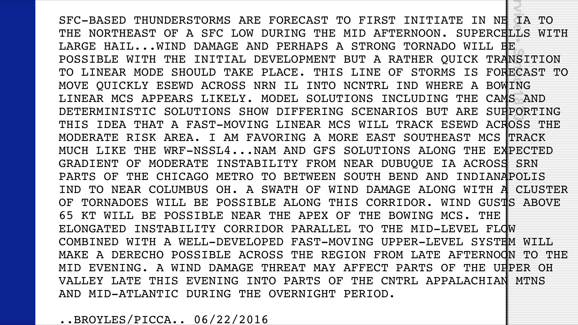
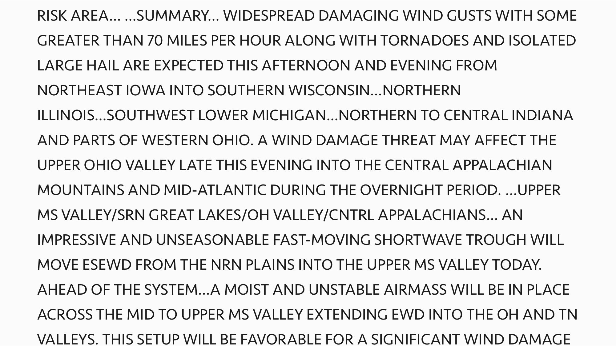
The NAM and GFS models are still calling for a big event today:

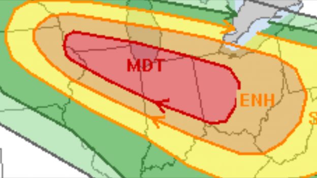
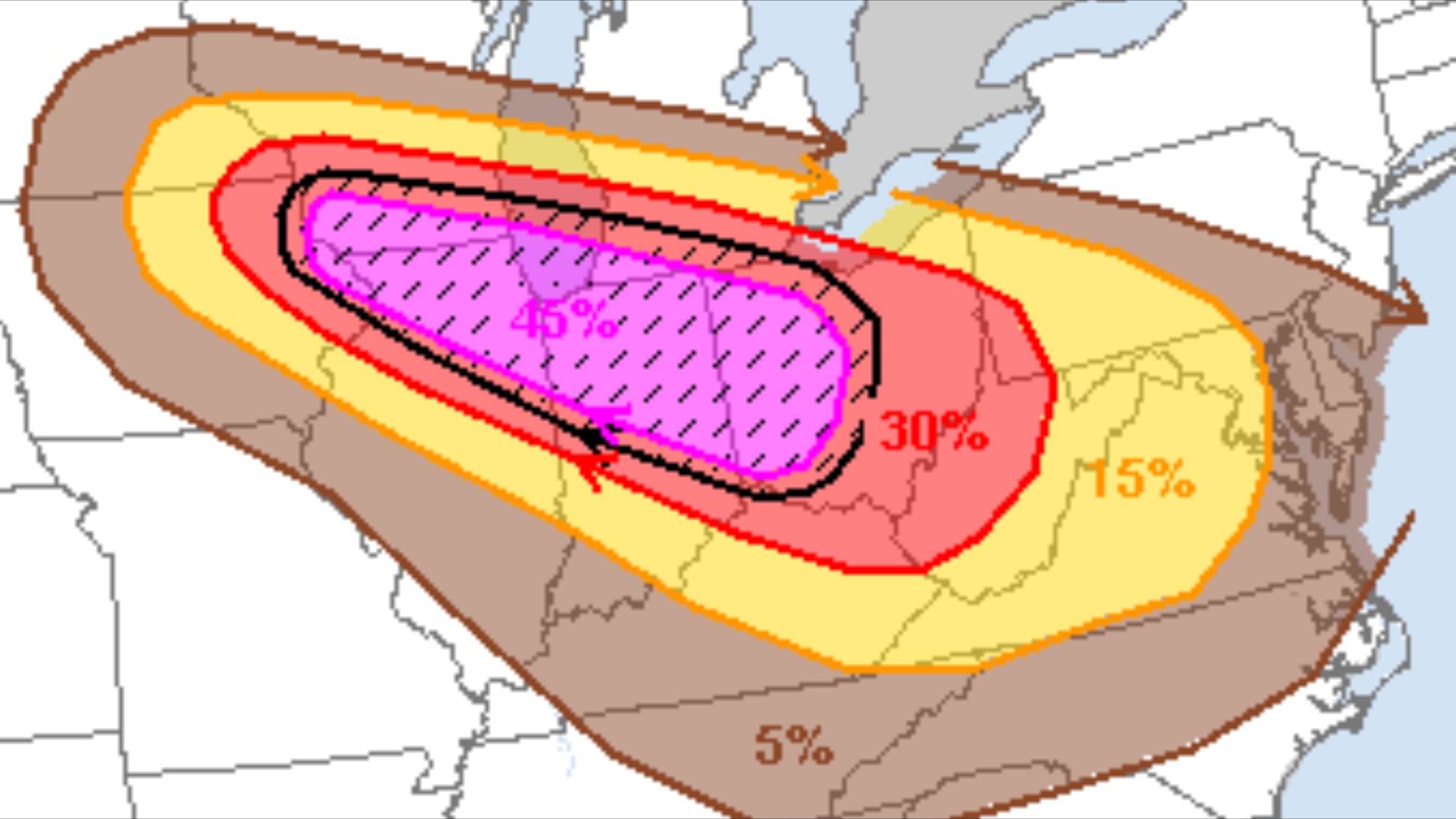
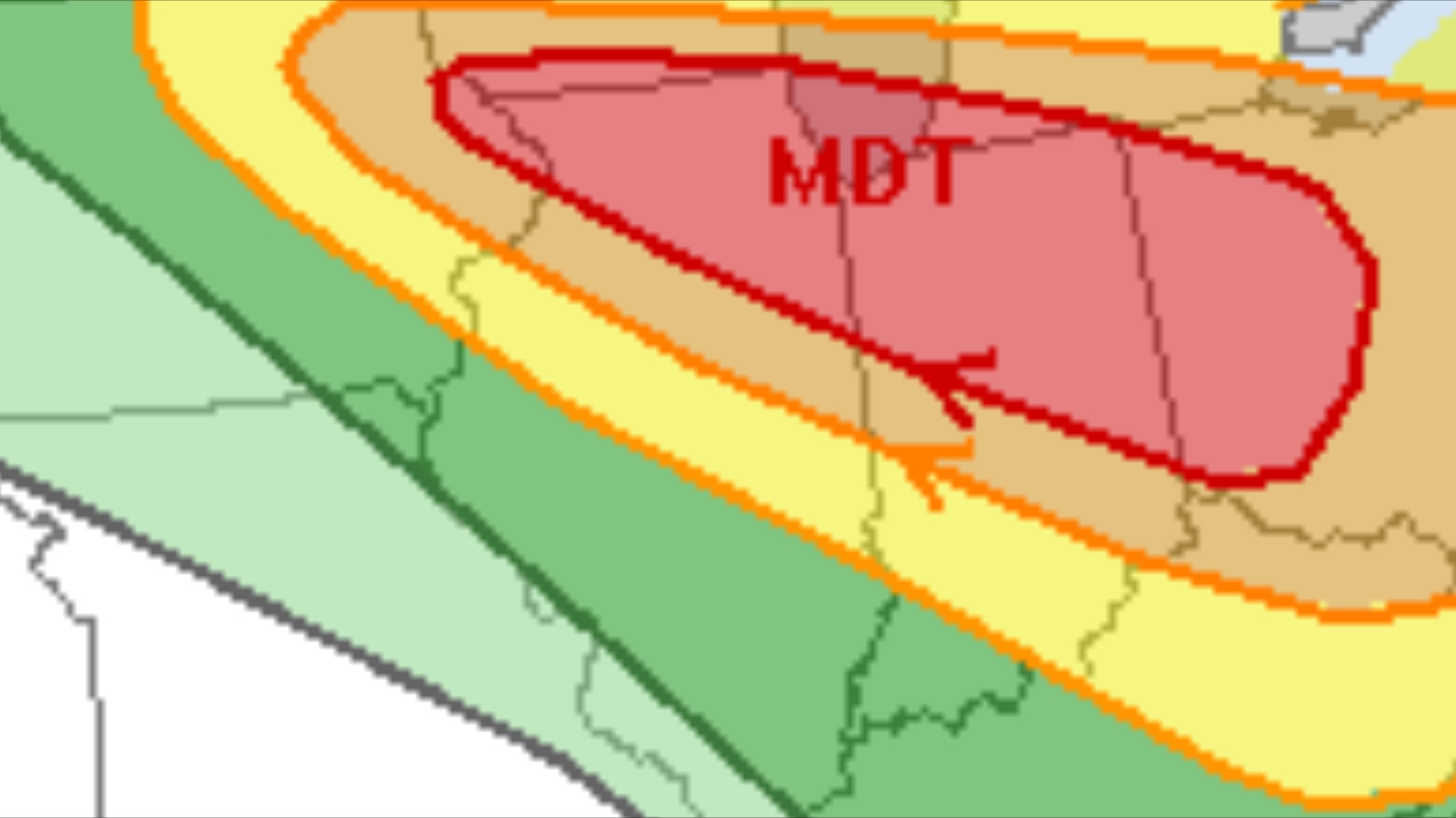
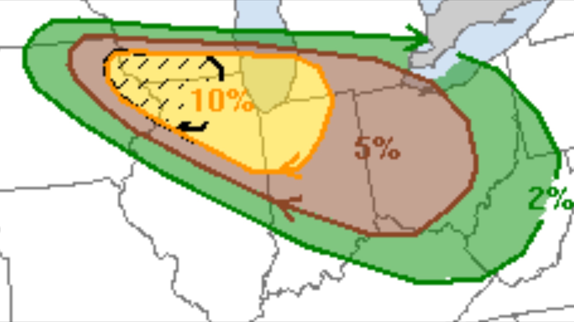
The current tornado probability [for the day as a whole] looks like this:

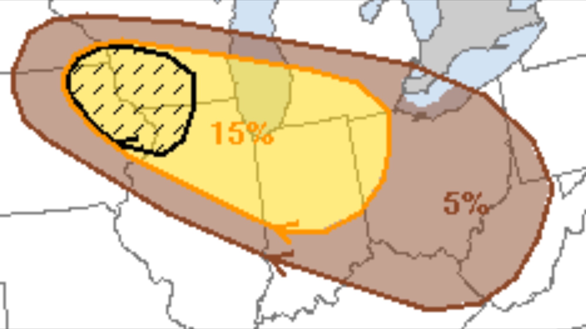
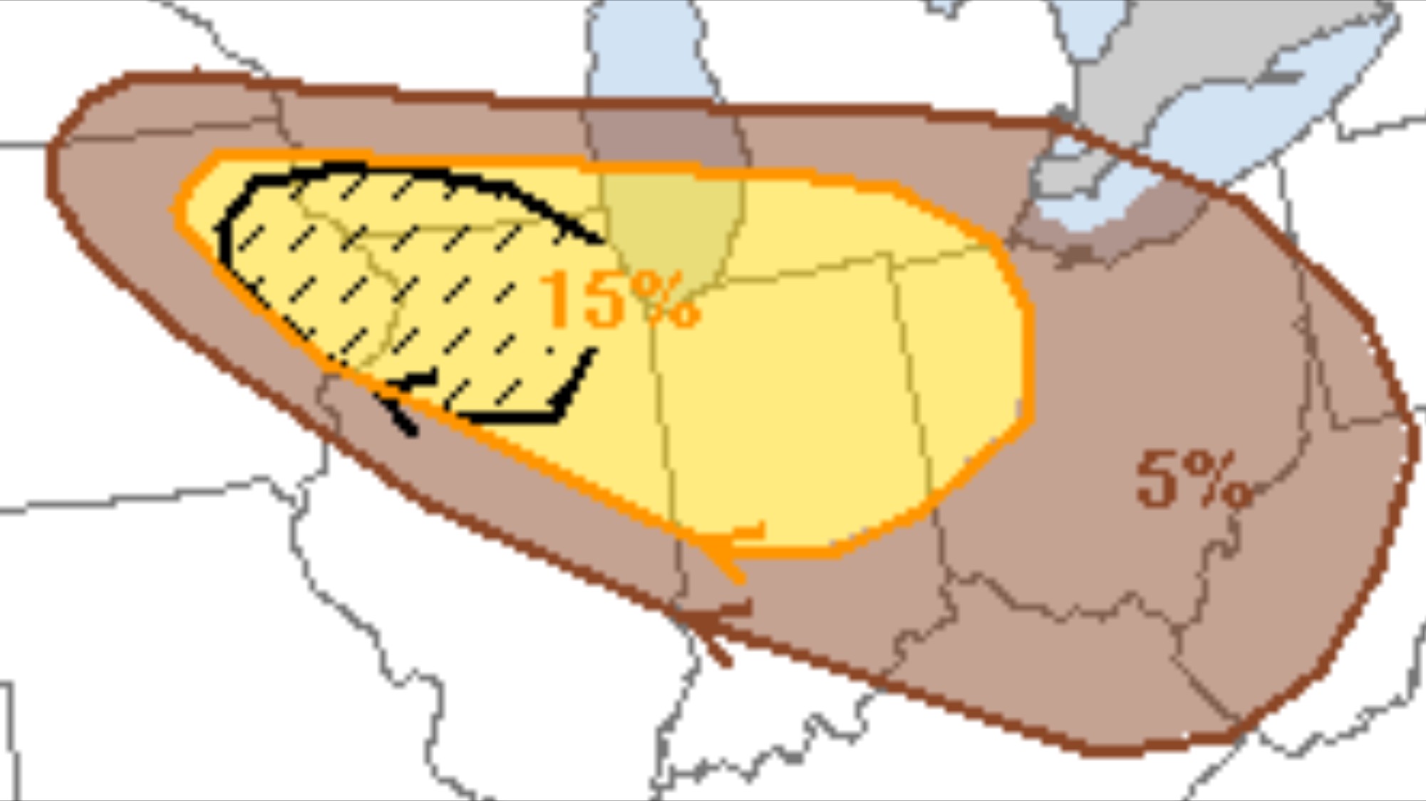
Severe wind probabilities for the day are as follows (per the 4 AM models):

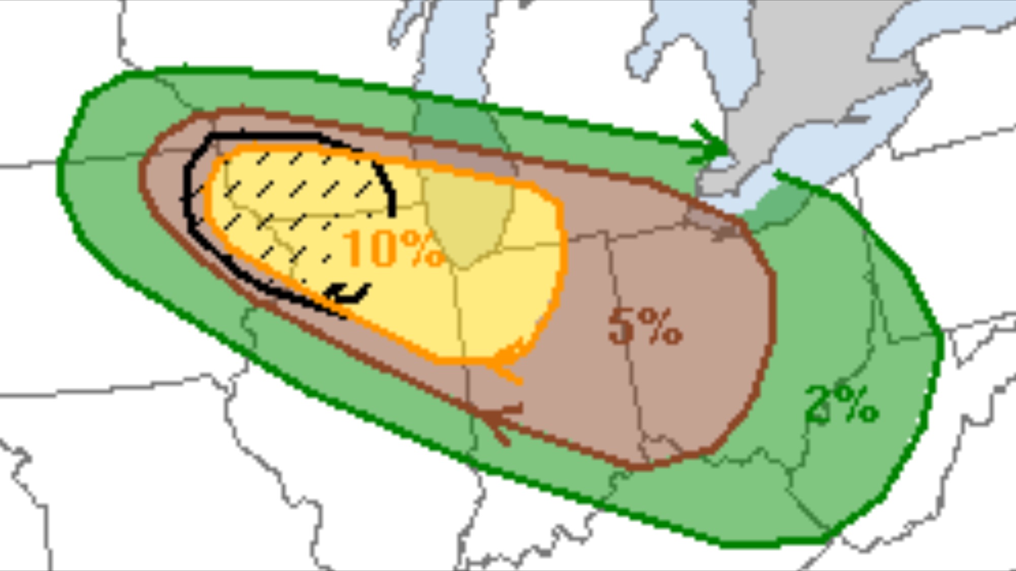
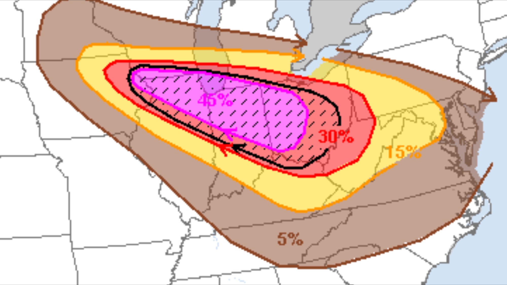
And severe hail looks like this, per the same forecast for the day:

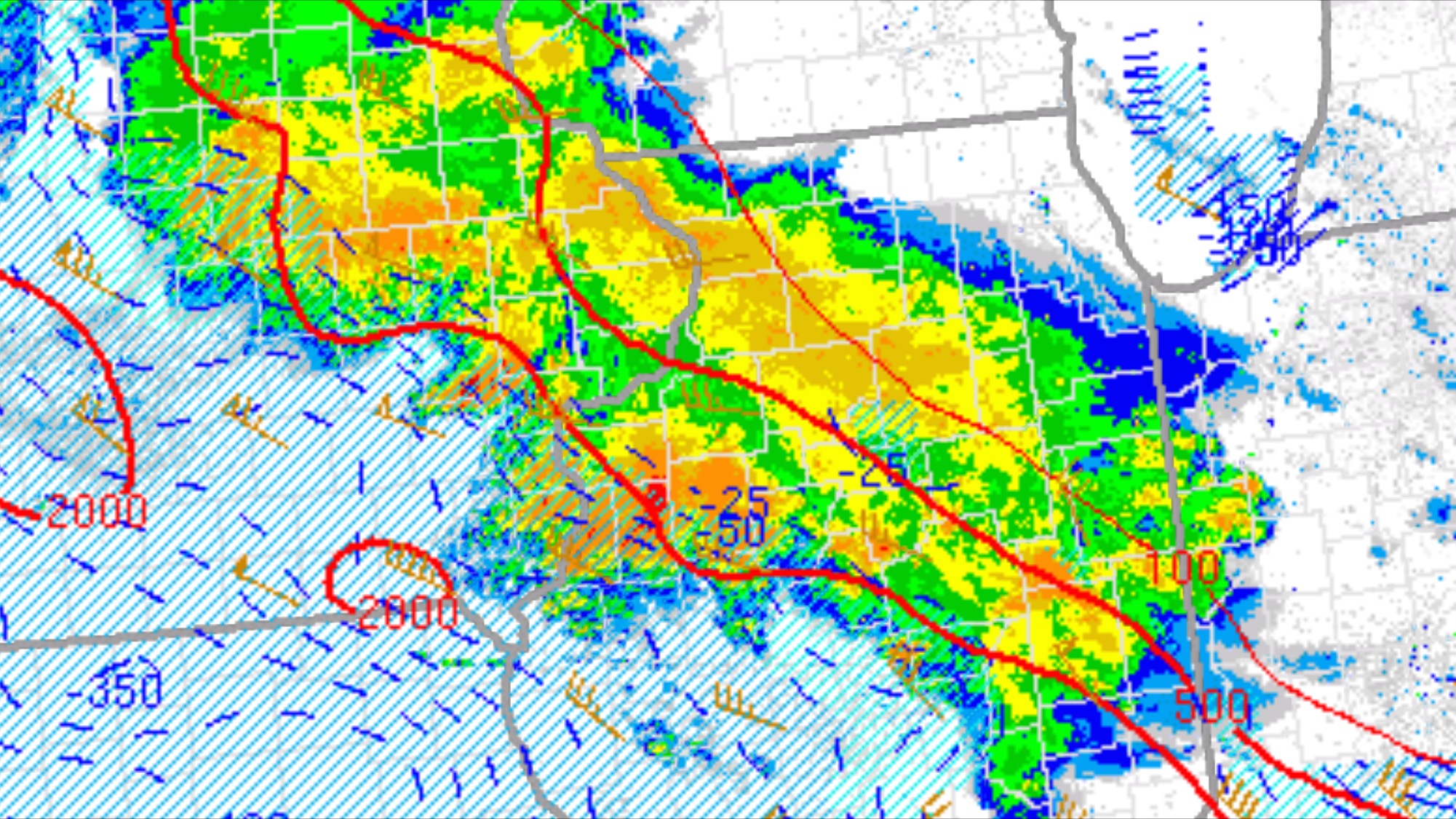
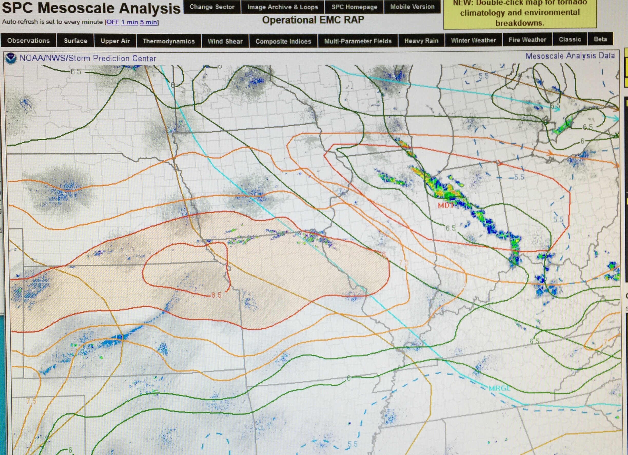
Current weather looks like this:

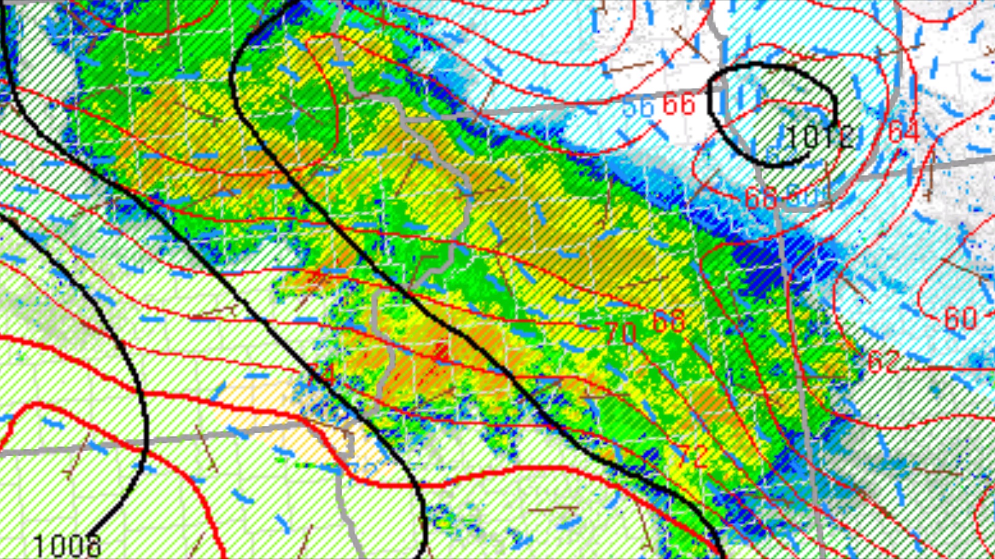
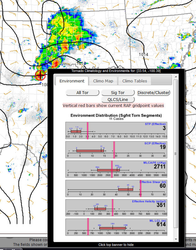
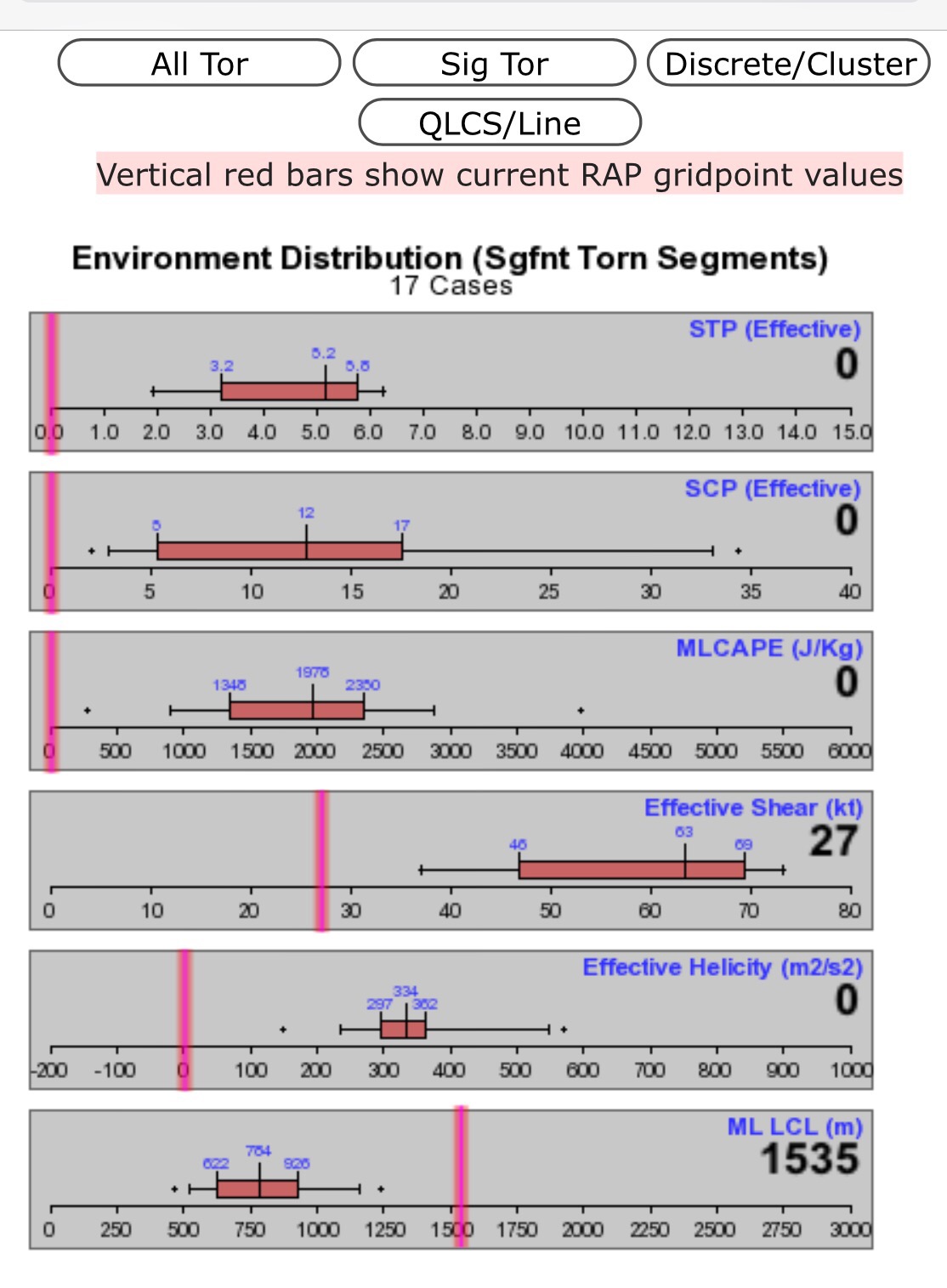
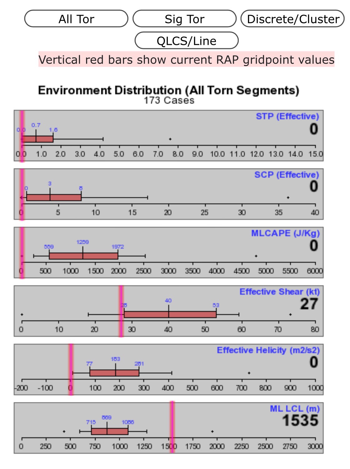
And the tornado parameters at the moment are well below any kind of threat threshold:

I will be watching these carefully as the day unfolds.

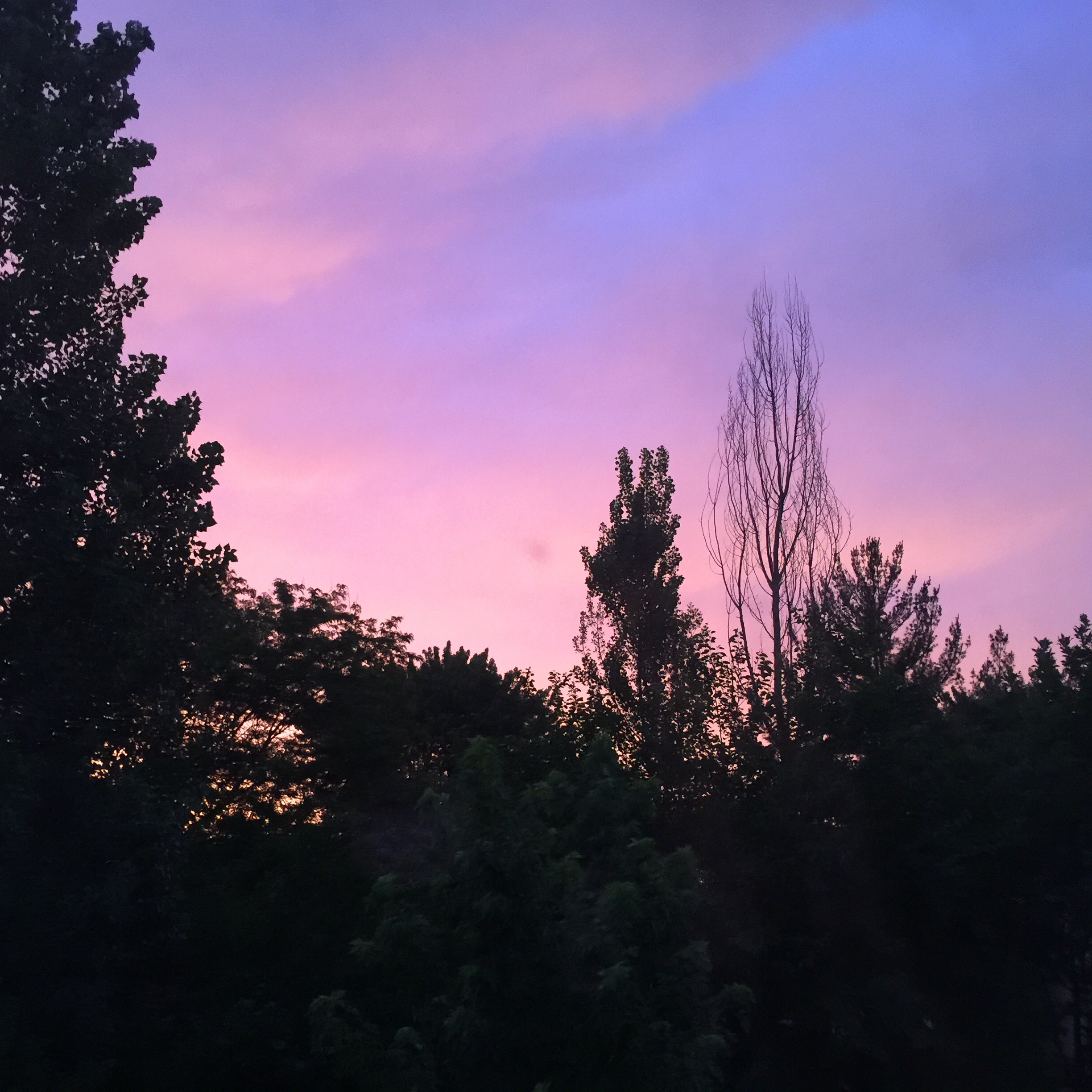
The sky was intensely red a moment before I took this picture, but it recalls the old expression “red in the morning, sailors take warning.”
8am – updates to the maps above show little change:


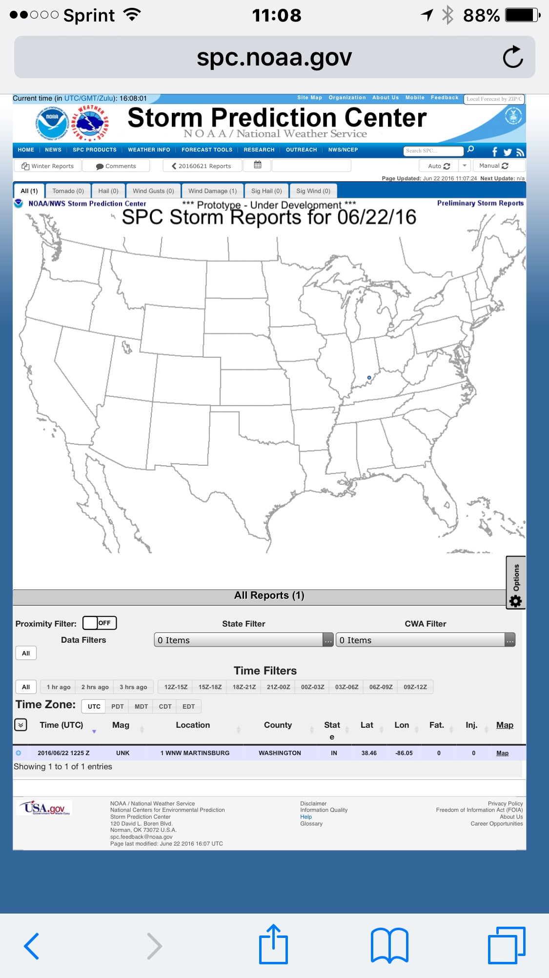
Up to this point, nothings severe reported:

15:10 – Arrived at the Naperville emergency operation center (DOC). Started up the weather computers and radios, in preparation for arrivals about their staff later in the afternoon. Traded in my XL size polo shirt for a new uniform shirt in a medium. (Doing a happy dance on the inside!)

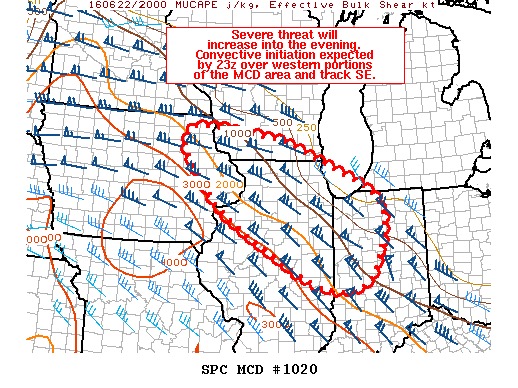
15:35CDT – An axis of steep lapse rates is oozing east from Iowa.

1730 CDT – Looks like a tornado watch is imminent, per mesoscale discussion MD1020.

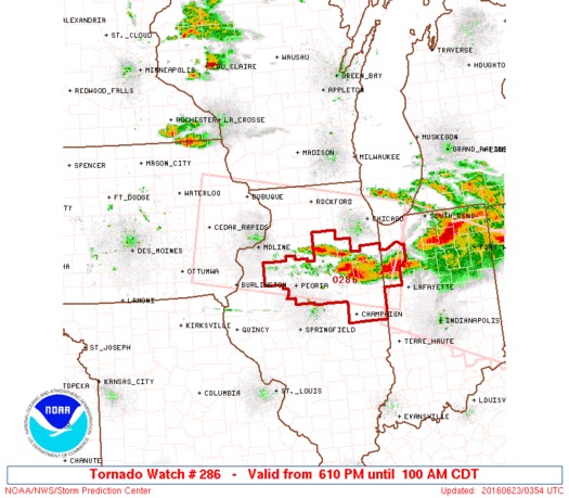
1810 CDT – tornado watch number 286 is issued. The EOC goes into operational mode.

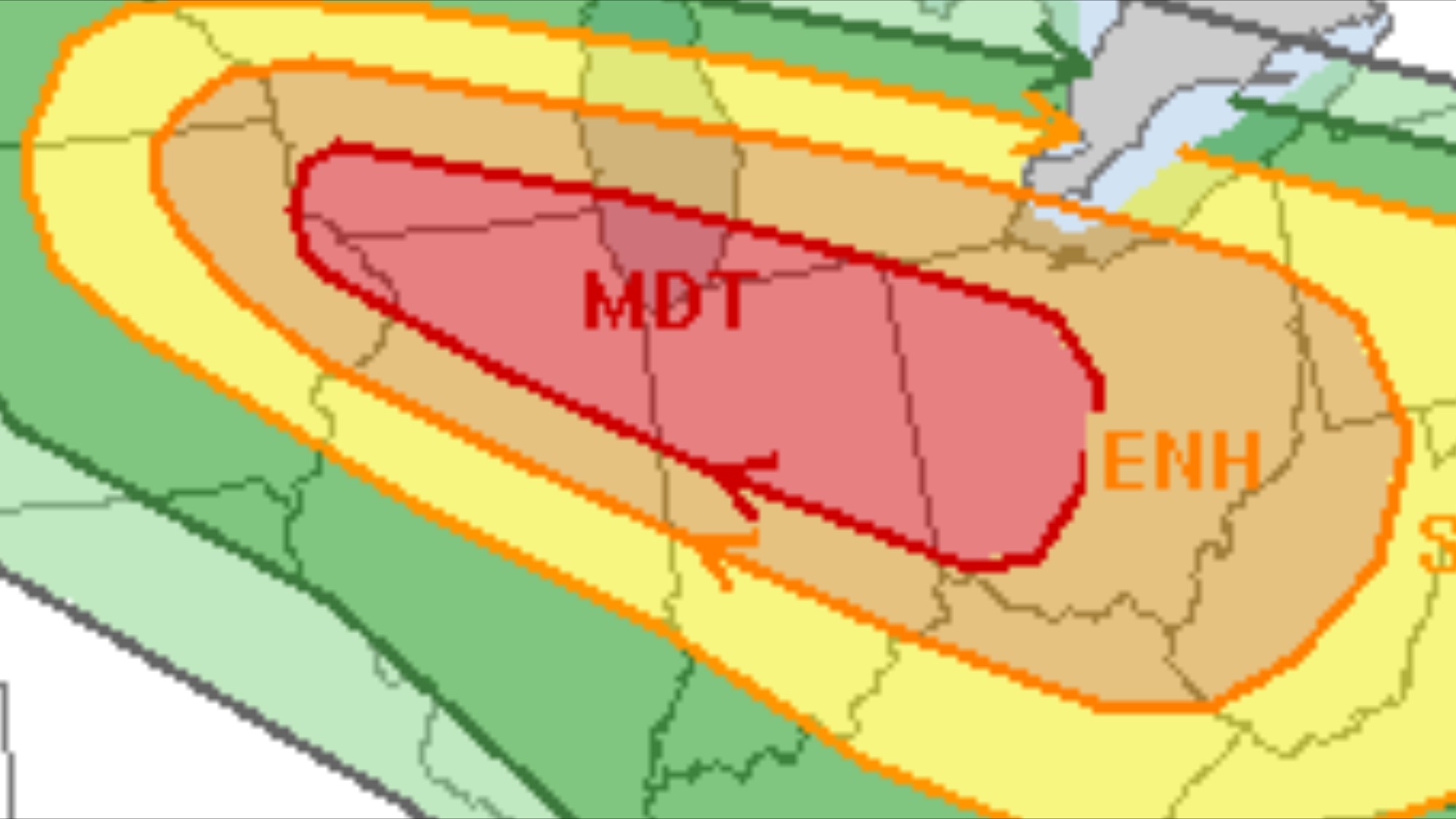
While the situation could change from the forecast above, I heave a sigh of relief that the primary area of a risk is to the south of the Chicago metro area. Had this been forecast to occur 25 miles further north, the situation could have been very dangerous for the western suburbsand Chicago proper. Once again, we dodge the bullet, it seems.

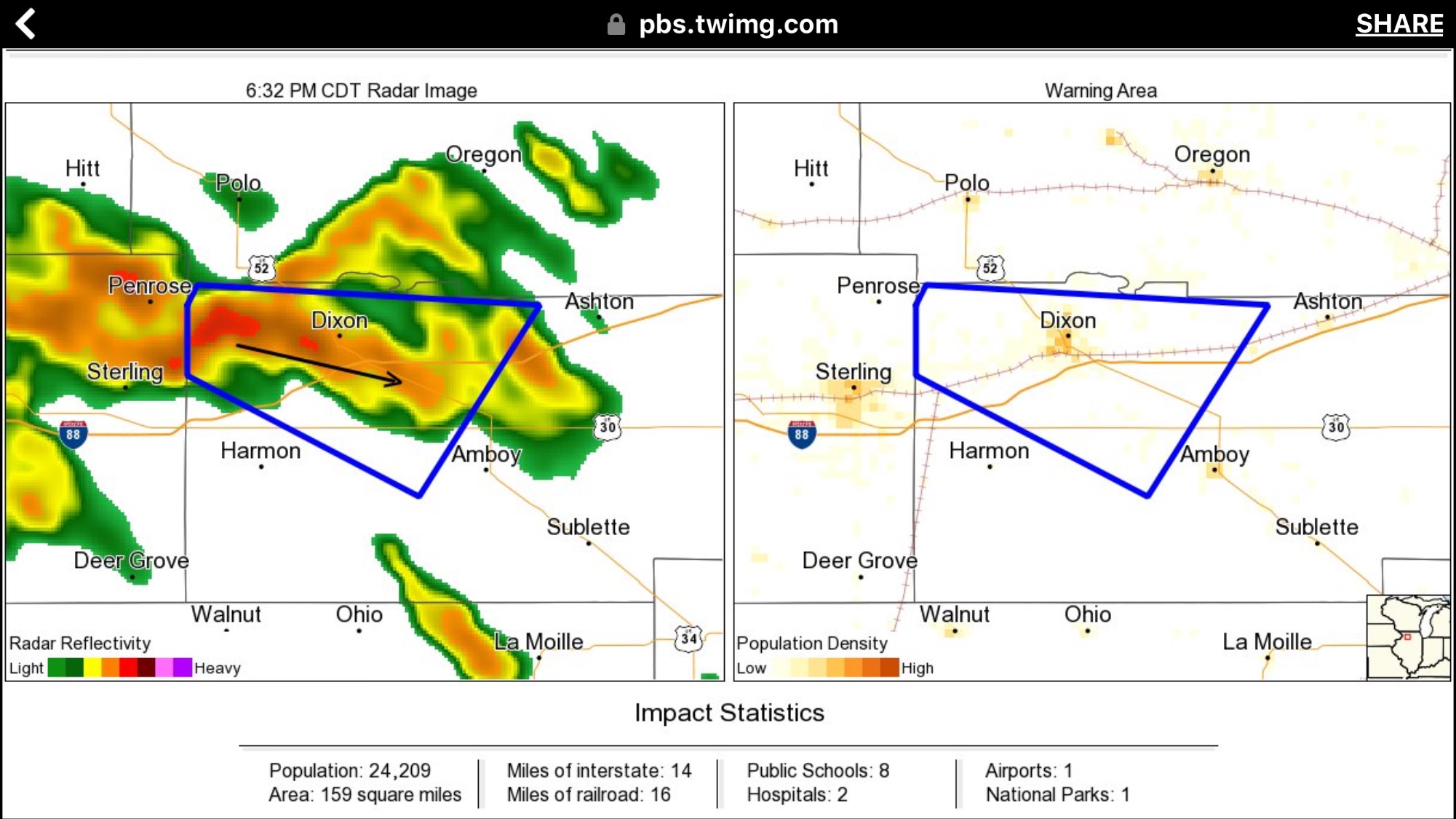
1834 CDT – A severe thunderstorm warning goes up near Amboy, Illinois. Even at this point, Al Fisher and I spot a strong couple of forming on the base philosophy velocity plot.”Why aren’t they issuing a tornado warning on this,” we ask one another.

A few minutes later, that warning is issued. NWS policy states that once a storm is tornado-warned, it retains that warning until the storm falls apart. This is how the NWS errs on the side of caution.

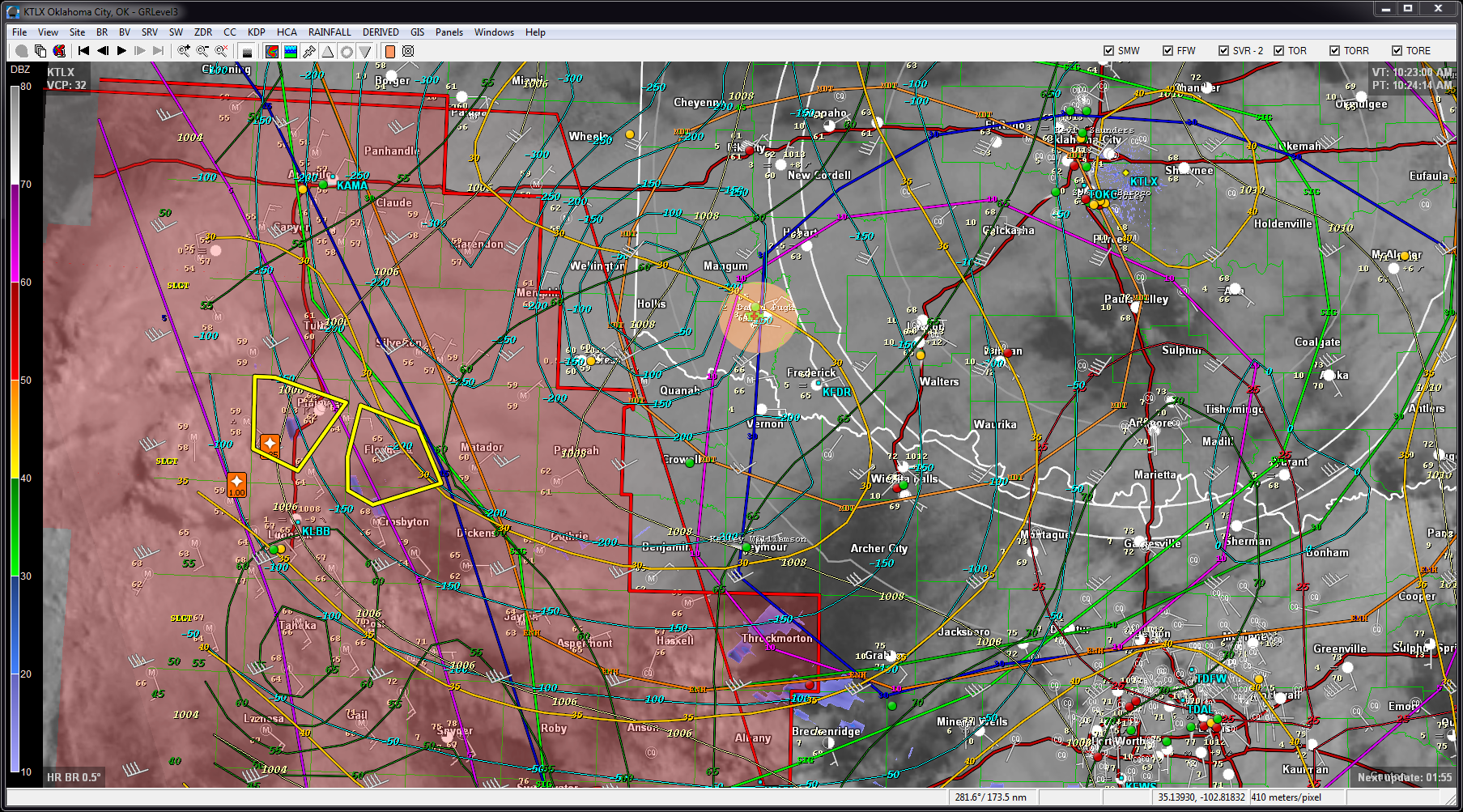
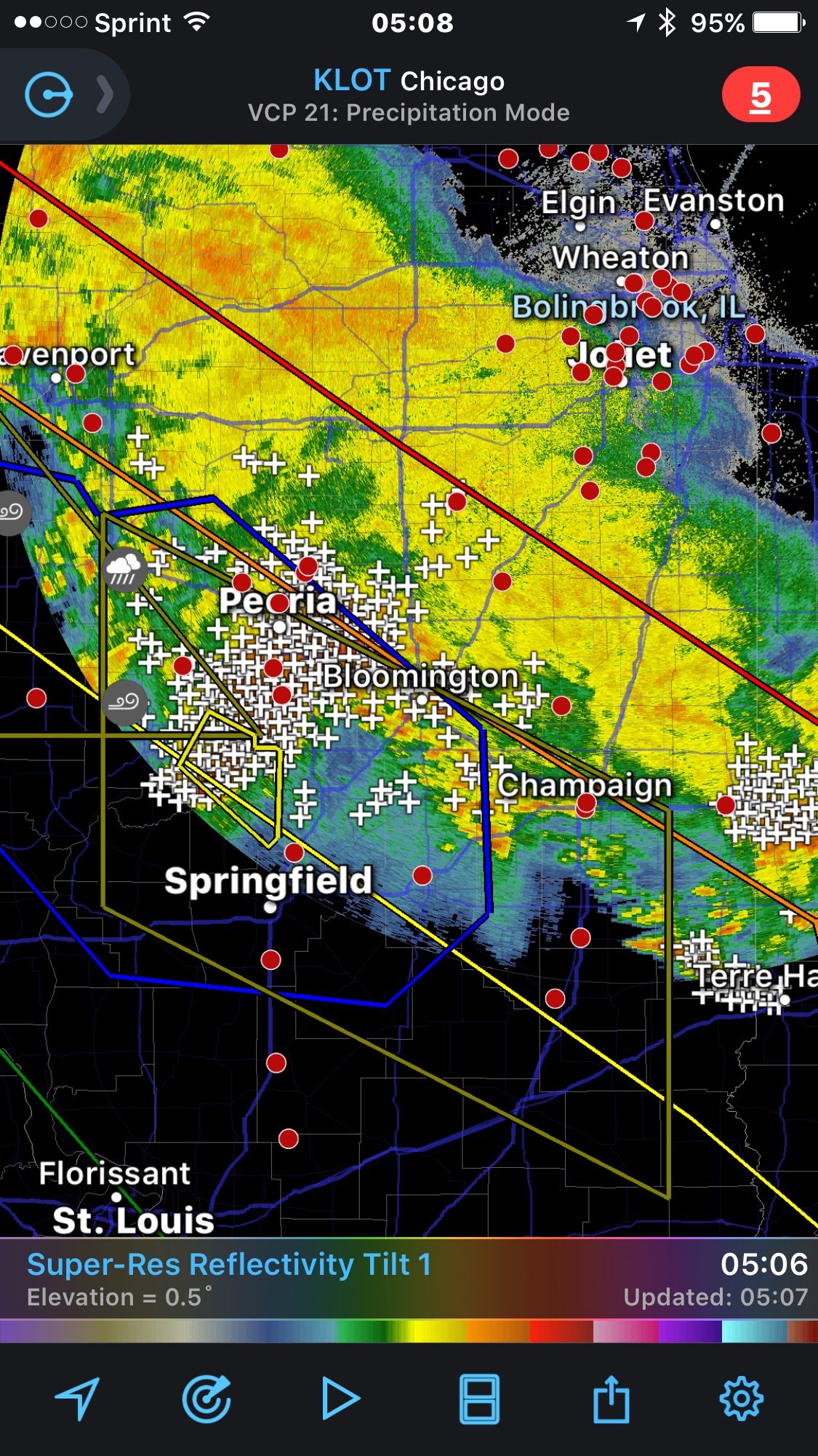
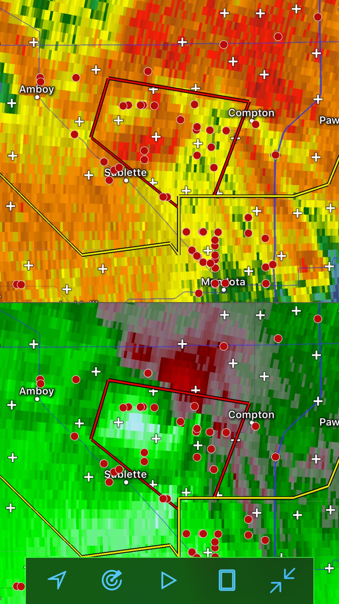
The good news is that they are able to issue this with a high degree of confidence, as a number of spotters and chasers (the little red dots in the picture below) are already on the storm, As this radar scope pro composite reflectivity/base velocity product shows:

(Photo courtesy of Ethan Mulnix)

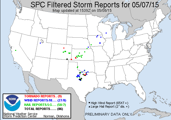
This tornado was the first one in a series strewn across northern Illinois. The storm reports (from later in the evening) show the path of the storm pretty clearly:

Chasers like Adam Lucio captured photos and video of other storms (at Marseilles, Illinois and further east). I will add links to those photos as I get a bit more time or the weekend.

(NWS has a preliminary page for this event up already.)

Virtual Chase – 08 May 2015 – Southwest Oklahoma

11:21: It’s only a few days until I chase in the physical realm, but the conditions are amazing today (and better tomorrow).

Based on a preliminary look at the SPC outlook, I’m focusing on my target area of a 25 mile radius around Altus, Oklahoma (the orange dot located in southwestern Oklahoma.

20150508-1033-GRLevel3

I’ll update this as the day rolls on. If I were there in the flesh, I’d likely be starting my day from someplace in southwestern Kansas (like Liberal, KS) rolling down US83 south to Altus.

Liberal,KS-Altus,OK

Here’s a look at yesterday’s action:
20150507-filtered-storm-reports(See also: http://www.spc.noaa.gov/climo/reports/150507_rpts.html)

1603CDT: My forecast has verified! check these radar shots (composite reflectivity):
Near Childress: TOR warning on storm rotation (not observed yet):

20150508-1600a-grlevel3Over Altus: BULLSEYE!20150508-1600b-grlevel3Strategy: watch the both storms. Stay with the Altus storm. Let the southern storm move toward me.

1630: Sheriff-nado at 16:23! (But plenty of chasers (Jim LaDue, Tony Mesias, David Drummond, others) are sitting on this storm attentively. (Local emergency management has another sighting at Oklaunion around 17:21.)

20150508-1630a-grlevel31640: TOR warnings dropped on the southern storm. Wait a bit longer, then slide east (to Anadarko, about an hour’s drive). Stay on the Altus storm.

1648: Course correction: Will go south at Lawton,OK (or north, if the Altus storm gets much stronger). Checking the tornado climatology rating on the Vernon (southern) storm: STP of 3+ !

20150508-1648-SPC-meso_torc_limo_envOk. Given that i was not watching the radar constantly, I’ve missed the better storm. Do I abandon the Altus storm or go for the larger storm (perhaps missing both)?
[Real world note: 2.75-inch fell at 16:11 in Caddo. Odds are that if I’d been there in the flesh, I’d have move east earlier instead of getting hammered by near-baseball size hail.]

17:14: The storm that was over Altus is fizzling. “Head south!”

17:38: Ok. Heading south on I-44 from Lawton to Randlett (36 minute drive), hoping to reach the Vernon storm in time.

GRlevel2 shows this to be a monster (looking from east toward the I-44 crossing of the Red River and beyond, to the west)
20150508-1738a-grlevel2


17:48: Pulled off at Walters, OK exit. Have to let the storm slide on by. I arrived too late!
Oh, well, tomorrow is another day. (Will circle back to Lawton for dinner, hotel, etc.)

END RESULT: A strong storm at my target, but the storm of the day is further south.


CHASE2014: Season Plan/Summary

Here is the overall plan for my 2014 storm season (which I’ll update as events warrant):

CHASE 2014 DAILY JOURNAL

DATEDAYSTARTENDMILESREMARKSSEMINARS/CLASSROOM TRAINING: 14 FebruaryFridayBolingbrookILDenverCO-ChaserCon2014-minilogoChaserCon 2014 – day 1 (convention)
http://www.chasercon.com/15 FebruarySaturdayDenverCO—ChaserCon2014-minilogoChaserCon 2014 – day 2 (convention)
http://www.chasercon.com/16 FebruarySundayDenverCOBolingbrookIL-ChaserCon2014-minilogoChaserCon 2014 – day 3 (convention)
http://www.chasercon.com/11 MarchTuesdayBolingbrookILNapervilleIL-nexradNaperville EMA
Radar class (#1 of 3)
Weather Command Class I
http://www.napervilleema.org12 MarchWednesdayBolingbrookILNapervilleIL-nexradNEMA Spotter Training (mandatory)
http://www.napervilleema.org15 MarchSaturdayBolingbrookILWheatonIL-nexradDuPage OHSEM Advanced
Spotter Training (seminar)
http://www.dupagesevereweather.com26 MarchWednesdayBolingbrookILNapervilleIL-nexradNaperville EMA
Radar class (#2 of 3)
Weather Command Class II
http://www.napervilleema.org09 AprilWednesdayBolingbrookILNapervilleIL-nexradNaperville EMA
Radar class (#3 of 3)
Weather Command Class III
http://www.napervilleema.orgTBAPOSTPONEDBolingbrookILNapervilleIL-first-aidBlood-borne Pathogens (mandatory)
http://www.napervilleema.orgSOUTHERN/GREAT PLAINS CHASES: mid-May: 4060 miles / 11 days

 09 MaySaturdayBolingbrookIL––Prologue10 MaySaturdayBolingbrookILOklahoma CityOK–TRAVEL11 MaySundayOklahoma CityOK—PLAYING TOURIST12 MayMondayOklahoma CityOK______DAY 1: ORIENTATION; DEPART BASE13 MayTuesday_________DAY 2: _14 MayWednesday_________DAY 3: _15 MayThursday_________DAY 4: _16 MayFriday_________DAY 5: _17 MaySaturday_________DAY 6: _18 MaySunday_________DAY 7: _19 MayMonday_________DAY 8: _20 MayTuesday_________DAY 9: _21 MayWednesday_________DAY 10: _22 MayThursday_________DAY 11: RETURN TO BASE23 MayFridayOklahoma CityOKBolingbrookIL___Homeward bound24 MaySaturdayBolingbrookIL   EpilogueIL/IA CHASES/SPOTTING: Chaser/spotter fun within 300 miles of home
(TBA)(TBA)BolingbrookIL(TBA)– VIRTUAL CHASES/SPOTTING: Like chasing without leaving home (or the office)
(TBA)(TBA)BolingbrookIL(TBA)–


COLOR CODE
Plan was to not chase GRAY
Planned Chase Day (future) YELLOW
Available to chase; no weather (“blue-skied”) BLUE
Chase Day (available and expect stormy weather) GREEN
Weather Stormy, but not available for chasing RED
BUST DAY – no severe storms where we looked!
ORANGE
Training Day
WHITE
Accommodations Restaurants Tools Web Links

NOTE: The restaurant and accommodations links will be dead until I get out in the field.

29 May 2013 – Virtual Chase – Hobart(KHBR), OK

A MOD RISK day in Oklahoma (but I’m working in Chicago), so we’ll chase virtually.

SPC’s tornado outlook has a big sausage-shaped area (hatched!) along western Oklahoma, but where do we target within a 96,000 square mile blob?

20130529-1300Z-SPC-day1probotlk_1300_torn

INITIAL TARGET: Hobart, OK


20130529-122145.jpg

VIRTUAL BASE: Salina, KS

RATIONALE: Looking over RAP and NAM (WRF-NMM) models, I see 30-40kt 500mb winds over southwest Oklahoma.

20130529-1200Z-RAP-uc12hr_500_wnd

Checking this vs. the Dew point, moisture convergence, and CAPE/CINH, the area from the southwest corner of Oklahoma to Weatherford, OK looks like where I’d predict a good chance to strong tornadoes. Using the NAM model, I see precipitation broken out for my target area during the 18-21Z area.

20130529-1200Z-NAM(WRF-NMM)-eta21hr_sfc_prcp

0840CDT: If I started from a virtual base city of Salina, KS, I’d be at the waffle maker at someplace like the Days Inn Salina South reviewing these models.
My departure would be at about 9:30 a.m., with an estimated arrival at Elk City, OK of about 3 pm (a 5.5 hours drive via I-35S and I40W).

0853CDT: METAR at Salina: KSLN 291353Z 19015G27KT 10SM BKN020 23/19 A2968 RMK AO2 PK WND 15031/1307 SLP038 T02280189=
Translation: 73 deGF and mostly cloudy. A brisk S to SSE wind at 17mph with gusts to 31mph. 1004mb pressure. Dewpoint is 66F already. “Air you can wear.”

13:34CDT: In the virtual world, I’m stopped to gas up for the afternoon near El Reno,OK, make a bathroom stop, and re-assess conditions. I regret having to bypass Moore, for a look from I-35, but I’ve headed west on I-40. I can’t observe the sky in the real world, but the surface map, visible satellite, and webcams give me an idea what I’d think if I were there: continue west for now, then re-assess at 14:30 or so.Temperature at El Reno is 77F with a *screaming* 68F dew point, scattered clouds, and a healthy 27mph wind.  It seems that moisture is getting carried WAY north of my position. But, I also need to be patient!

Maybe I’ll stop at Sayre, and consider going north, as storms are already popping west and north of there. A huge TOR watch area — the red shaded area in the map below— covers much of western Oklahoma and continues north into Kansas (where a really long line of chasers are heading west on US54, apparently try to catch the storm straddling the Clark-Comanche county line, south of Dodge City).

20130529-1343CDT-KFRD-radar-CR-ET

Now the hard part: do I abandon my original target or hope the southern storms produce. Choices, choices, choices!

14:00CDT – After watch radar and checking SBCAPE, I decide to abandon my target. Tall, ferocious storms are building on the OK-KS line, head up through Watonga on US270W, hoping there are still storms to chase around 16:00CDT.  Supercell composite is 12 for the area.  Hopefully, I can make good time without getting a ticket. *Looks both ways, crosses fingers*

16:00CDT: Look like storm to the south is picking up. Dropping south to Seiling,OK

1630CDT: Storms east and west. Will stick with the westerm storms, aiming for the ‘tail end Charlie’. Head south on US183.
Problem: Not many road options until Clinton!

1730CDT: I see (from GRLevel3) that Vic Gensini from CoD is on the storm by Memphis, TX.  I’m going to let it come to me. It’s adjacent to the new ‘tail end Charlie’ to its southwest. *crosses fingers*

20130529-1725CDT-KAMA-CR-ET

[NOTE: Real-world issues have interrupted. I may have to break off this virtual chase.]

RESULT: A work-related crisis took me away from this virtual chase, but I would have reached sever storms in any case.
There were several tornado reports nearby, but odds are that I would NOT have seen them.  As the map below indicates, most of the significant tornado action occurs north and outside of the originally predicted sausage-shaped area of high tornado probability.

20130529-preliminary-storm-reports


20 May 2013 – Virtual Chase – Comanche, OK

Today will have to be a virtual chase day. My chase-cation is over and the weekend is behind me.
Hopefully, I’ll a) be available to chase next weekend and b) there will be severe storms with 500 miles of home during that time.

In the meantime, on with the virtual chase:

FACTOR REAL CHASE VIRTUAL CHASE THE DIFFERENCE
Breakfast High-carb feast: Carbon; brand waffle machine, sugar-free syrup, orange juice, fruit (if I’m lucky) 20130520-090143.jpgProtein bar, Low sodium V-8, sparkling water Gotta eat leaner when I not running around, toting bags of gear and clothing, etc. Virtual chasing gives me more choice, however.
Forecasting Always another opinion 20130520-090252.jpg
Just my own ideas and opinion.
I use the same technique: check the SLIM factors: shear, lift, instability, moisture.
I look at the SPC convective outlook maps and text for the day then try to identify what
they’re discussing on the NAM, WRF, RAP, HRRR models runs.I check the visible satellite pictures to see what sort of clearing and morning storms I have.  I peruse logP-skewT charts around my target area to gauge what sort of moisture and wind setup I have.
I see where storm ingredients come together between 18Z (1pm CDT) and 0Z (7pm).
Since I’ve shadowed Bill Reid and seen so many of his forecasts since 2002, I try to do as Bill does.
(It’s served me very well, but I get too little storm time in the Great Plains to really boost my skills in the field.)
Computing / Comms Resources My iPhone (RadarScope, MyWarn, etc.), my MSI Wind U120 netbook (1GB RAM, Windows XP, GRlevel3, GRLevel2Analyst, StormLab, Delorme Street Atlas, Davis WeatherLink), Sprint MiFi, connectivity prayers 20130520-090111.jpg

20130520-090128.jpgAll of the above, plus numerous 25-inch screens, quad-core desktop (Windows 7, 8GB RAM, all of the software on the netbook), 25Mbps internet, business-class high-redundancy router

More screen real estate and speed at home. My mobile gear has done well over the years, however. (Time to upgrade that 2009-vintage netbook next season, too.)
Watching the sky Observe the sky directly. In the early Doswell days, the ability to read the maps was a beginning, but the ability to correctly read the sky often determined Use fixed webcams across the web and (closer to storm time) streaming video from Spotter Network members to see what’s happening in the real world.
Obviously, the latter will introduce the bias of the person streaming the video, but I have a few favorite streamers to follow.
I feel we all have biases, so I try to choose mine carefully *smiles* .
Mo’ sky, mo’ bettah

Assumed base city: Wichita, KS (so I can join Jim, Jenna and Woodrow for the morning Starbucks run 🙂 )
Initial target: Comanche, OK

20130520-081032.jpg

Basis:
(Verbiage to be added later. Short version: Looks to me like shear, lift, instability, and moisture all come together in south central OK around 20Z. Charts follow.)

Factor Remarks MAP 1 – 4-6pm MAP 2 – around 7 pm MAP 3 – after 7pm
_ _ _20130520-075738.jpg _20130520-075730.jpg _20130520-075719.jpg
_ _ _20130520-080008.jpg _20130520-075953.jpg _
_ _ _20130520-080051.jpg _20130520-080051.jpg _
_ _ _20130520-080136.jpg _20130520-080122.jpg _
_ _ _20130520-075839.jpg _20130520-075812.jpg _20130520-075746.jpg
_ _ _20130520-075944.jpg _ _20130520-075902.jpg

20130520-12Z-UA-OBS-LMN

1230 – A look st the SREF as I sit down to lunch (in both the virtual and real world) gives me pause for thought. It appears that Comanche, OK may be a bit to far southwest. In the virtual world, I’m at the Lawton Golden Corral (2632 Northwest Cache Road, Lawton, OK 73505) getting a good meal, as it looks like I won’t have a sit-down supper tonight. Suppertime is storm time, so I’ll be munching jerky then (albeit carefully, thanks to a temporary crown my dentist repaired on Saturday … in the real world.) Looks like I’ll need to relocate east then north; better keep lunch down to 15-20 minutes. Time to re-evaluate after lunch.

20130520-17Z-valid00Z-SREF_prob_front_mpv_2__f015_ _20130520-17Z-valid00Z-SREF_prob_hicape_2000__f015
_20130520-17Z-valid00Z-SREF_SCCP_MEDIAN_MXMN__f015 _20130520-17Z-valid21Z-SREF_prob_combined_0.01_40_2000__f012
_20130520-17Z-valid00Z-SREF_12HR_SVR_PROBS__f015 _20130520-17Z-valid00Z-SREF_prob_2mdewpt_60F__f015


1250 – I slide east on OK7, then north on US81. Around 1330, ‘virtual me’ gives a wave to Jeff Piotrowski who’s eying the storm that’s gone up between Comanche and Lawton. (I’m always encouraged when I see somebody who really knows what they’re doing. It makes me feel a tiny bit more like I do, too.) Soon, the storm is shooting down some lightning and looking somewhat energetic.

Here are radar images of the storm, which produces a tornado later (though not as large or (thankfully) as deadly as the Moore, OK tornado of later today.

kfdr_20130520_2002a

kfdr_20130520_2002

kfdr_20130520_1915

20130520-1422C-KFDR

20130520-1513C-KFDR

20130520-1516C-KFDR

20130520-1520C-KFDR