Casualties of Travel?

(excerpt from a letter to my fellow travelers)

Hi, Guys!

I just wanted to check in with all of you. I hope you enjoyed the trip. I will have my pix up on Flickr at http://www.flickr.com/photos/polarpal99/collections/72157605566660377/ by the end of the weekend.  (You’ll get an invite to Flickr group “CHASE2008-polarpal99” shortly for access).

For my part, this was a pretty expensive trip (vs. last year, which was comparatively painless). Casualties of travel include:

* Pentax ZX-5 SLR camera – jammed up … time to go all digital next year, I guess

* Acer laptop – Windows XP eating itself … time to back up and re-install (once I procure the install CD … it didn’t come with one, sadly). When I do re-install, I will probably lose access to GRlevel3 (but probably should register after using Alex’s key for the last year, right?)

* Novatel broadband modem – dead (but I had insurance, so a free replacement is coming).

* Vehicle damage – $1200 damage to sub-frame, gas tank and one of the boots.

At any rate, I hope we can vacation together again next year. I also hope you will understand my reluctance to travel the back roads when we have other options, too; this van situation has me pretty freaked out.

Rgds,
lisa
EPILOGUE – Licking my Wounds – 20080609

[NOTE: I am in the process of transcribing numerous paper notes from the trip. I hope to have the blog caught up before the coming weekend. I’d be caught up already, if not for several issues with my laptop and its broadband modem over the last week. *sigh*]

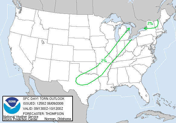
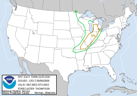
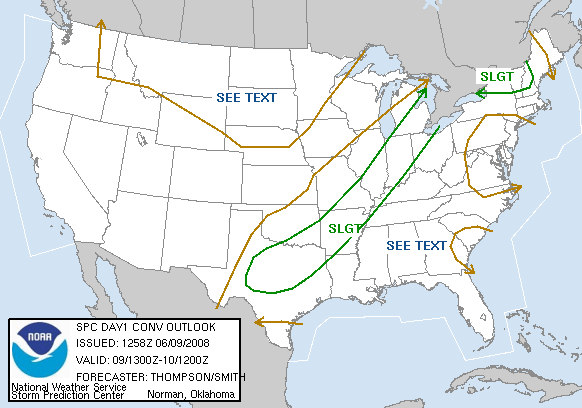
The morning SPC outlook maps looked like this:

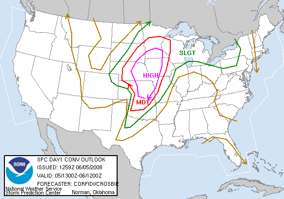
CONVECTIVE OUTLOOK:

1300Z Convective Outlook for 2008/06/09

TORNADO OUTLOOK:

1300Z

SUMMARY:

  • 0700C – Wake up! On the second morning since my neck got so stiff that i was barely safe for driving the van, my neck pain has only subsided a little,
  • 0900C – Look over the weather models. No cause for excitement: the nearest area of even slight risk is either (a) about 4-5 hours south, along I-57 (in Illinois) or (b) 3-4 hours east (in Indiana). I decide to stay put and unpack, regroup, etc.
  • 1000C – I try to get my broadband modem working with a different laptop, a Toshiba Satellite M55-S139. No good! The broadband modem appears to be dead, perhaps a casualty of too much ‘road wear’ over the last year.
  • 1100C – Clean up the van. Since the guys I travel with are relatively neat and helpful, collecting the trash from the trip only takes about 30 minutes. I also do some sweeping to remove the road dust, including a strip of Kansas dust an inch deep around the seal of the rear hatch. Thanks goodness the door seals are great!
  • 1230C – At Scott’s suggestion, I try to rearange the seating a bit.  As it turns out, this is a major ordeal! The center console (full of radios and wiring and such) blocks the Stow-n-Go panels so completely that folding a seat into the floor is impossible. (Insert much waving of arms, cursing, etc. here Yell) After partially dismantling the radio setup, moving the from seats as far forward as they’ll go, and moving the back seats as far back as they’ll go, I can finally foce the right seat (in the second row) into the floor.  At one point it gets jammed against both the movable floor panel and the front row seat; I resort to using a garden shovel handle for leverage to pry it out of the seat well and try again. On the third try, I discover the secret:borow one of the legs of my laptop ‘table’ and use it to jack up the center console to create better clearance for the flor panel. A firm shove finally gets the seat into the floor. Over two hors after I’ve started, the job is done.
  • 1500C – Grab lunch at the Red Lobster.
  • 1600C – I visit the Sprint store to see what can be done about replacing my broadband modem. Fully expecting to shell out several hundred dollars, I quietly describe my observations about the device and all I’ve done to get it working.  The sales rep checks my account and gives me good news: I paid for insurance on the gadget! I’ll have to wait two days for the replacement to arrive, but I will not pay a dime for the trouble (and the storm pattern looks uncooperative for most of the next week, so I can afford to wait). Thank God I paid for that replacement plan insurance! (I usualy opt out of such coverage.)
  • 1650C – I call my Chrysler deal for an appointment to look at the fuel system issue we experienced on the trip. I get a Wednesday appointment, first thing in the morning. I return home, fingers crossed that the warranty covers the problem (i.e., that i do not face a big repair bill).
  • 1730C – I continue to empty stuff out of the van.  I find a metal plate just big enough to accommodate my antenna farm inside the van, so I put the antennas on the plate, in preparation for a visit to the car wash (to get the rest of the road dust off the van)
  • 2030C – I grab dinner. Man, am I tired!
  • 2200C – Turn in for a night’s sleep

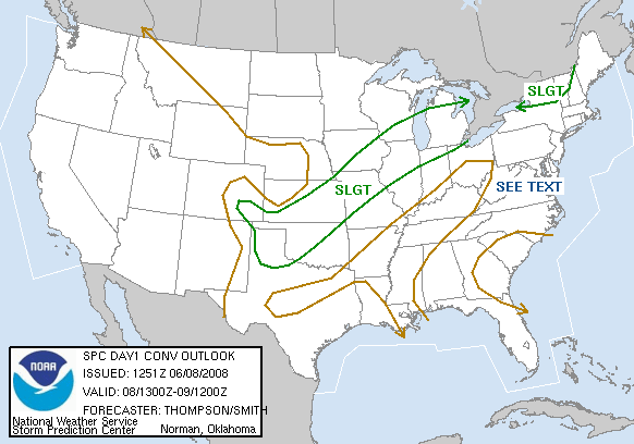
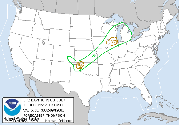
DAY 16 – The Road Home – 20080608

The morning SPC outlook maps looked like this: 1300Z 1300Z

  • ____C – (TBD)
  • 1000C – Daily Briefing:
  • 1030C – Left __________ Motel at _________, __ , moving toward __________________________________.
  • ____C – (TBD)
  • ____C – (TBD)
  • ____C – (TBD)
  • ____C – (TBD)
  • ____C – (TBD)
  • ____C – Arrive at motel for a night’s sleep

ESTIMATED TRAVEL

START TIME START ODOM. START LOC.
09:00 CDT ______ Oklahoma City, OK
FINISH TIME FINISH ODOM. FINISH LOC.
23:30 CDT ______ Bolingbrook, IL
ELAP. TIME MILES TTL. REMARKS
14:30 ______ mi Includes 2 fuel/rest/snack stops

OVERALL – 2007 Town & Country

START TIME START ODOM. START LOC.
24 May 2008 4995 Oklahoma City, OK
FINISH TIME FINISH ODOM. FINISH LOC.
08 June 2008 ______ Bolingbrook, IL
ELAP. TIME MILES TTL. REMARKS
9 days (excl. time parked in OKC) ______ mi Includes 2 fuel/rest/snack stops

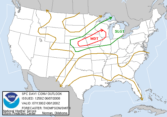
DAY 15 – Storm over Lake Oologah – 20080607

The morning SPC outlook maps looked like this: 1300Z 1300Z

  • 0700C – Check yeswterday’s storm reports. My target area produced tornadoes. Arrrgh!
  • 0800C – Showered and grabbed a quick con-brekkie. Grumbling a bit about our missed opportunities in Nebraska (and being too far south the play today’s illinois-Iowa options).
  • 1000C – Daily Briefing:
  • 1030C – Left Super 8 Motel at Pryor, OK, moving toward the ‘jungles’ of Oklahoma to chase marginally severe prospects and hope for some good photo opportunities.
  • ____C – Lunch at Braum’s ice creaqm parlor (imagine “Dairy Queen but with better food”).
  • ____C –  We stop at a convenience store for a bathroom break, refills on snacks, and to top off the tank on out way toward the Oologah  (“OO-luh-guh”)  area.
  • ____C – As we travel east acoss the bridge that bisects the lake, we see a photogenic hail core to our north and snap some photos and video.  We try to get another view past the east shore of the lake but we are totally blocked from the lower part of the sky by trees. “Welcome to the Jungle” (Oklahoma style).
  • ____C – We check out a camping area on the south side of Lake Oologah, but our view is obscured, so we move on.
  • ____C – We continue circling Lake Oologah, until we find a nice boat launch area just past the dam on the south end of the lake.
  • ____C – I’m moping a bit over yesterday’s disappointments, but a photogenic shot of the lake draws me outside. While I’m there, a superb rainbow forms over the lake. Everyody is snapping photos and taking video. Here is our shot of the day! I remind myslf that storms are only a part of the storm chase experience: one learns to appreciate the little miracles all around us. (Yes, I feel better now. Cool)
  • ____C – Arrive at our base motel, the Wingate near OKC airport.
  • ____C – We dine at Charleston’s, definitely more upscale than anywhere we’ve dined in a few days. The prime rib is every bit as deliciouis as I remember it (though the service was better when I was last here two years ago).
    (NOTE: I’ll have to use the timestamps on my photos to reconstruct the timeline here!)

ESTIMATED TRAVEL

START TIME START ODOM. S.TART LOC.
__:__ ______ (T1 Chase Van) Pryor, OK
FINISH TIME FINISH ODOM. FINISH LOC.
__:__ ______ (T1 Chase Van) OKC, OK
ELAP. TIME MILES TTL. REMARKS
__:__ ______ mi (T1 Chase Van) Base to our base city

Day 15 – Murphy’s Law in Action – 20080607

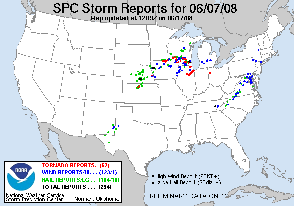
Murphy’s Law: You drive 7000 miles and see no tornadoes. Meanwhile, back home, a big tornado shows up.

While Scott and i were looking (independently)  at the forecast for tomorrow, Scott looked over the 07 June Storm Reports at SPC and called me about the Chicago area reports of a ‘large tornado runing parallel to I-55’. Here’s the map of what he saw:

June 7,  2008 Storm Reports

and the full storm report text:

http://www.spc.noaa.gov/climo/reports/080607_rpts.html

and the damage surveys: Results from Storm Surveys of June 7th Tornadoes

Side note: I am catching up entries for DAYS 11-17 from paper notes, which I had to take due to failure of my broadband modem and/or drivers on the road. (Bummer, eh?)

DAY 14 – One Last Chance for Storms – 20080606

The morning SPC outlook maps looked like this: 1300Z 1300Z

  • 0700C – Wake up and get con-brekkie
  • 1000C – Daily Briefing: ______ (I forget … not much to discuss, I suppose)
  • 1030C – Left motel.
  • OK – I LOST A DAY HERE! I’ll have to reconstruct it looking at receipts, photos, etc. – SORRY
  • ____C – Arrive at motel for a night’s sleep

ESTIMATED TRAVEL

START TIME START ODOM. START LOC.
__:__ ______ (T1 Chase Van) ______, __
FINISH TIME FINISH ODOM. FINISH LOC.
__:__ ______ (T1 Chase Van) Pryor, OK?
ELAP. TIME MILES TTL. REMARKS
__:__ ______ mi (T1 Chase Van) ______

Chipping Away – Part 1

*sigh* I’m chipping away at the beta site. I’ve build up a dropdown menu in the weather model page.  It should allow quick access to all the data one might commonly use while planning and executing a storm chase expedition.

As for my poor laptop — the other one— it is still in the shop, but I expect news of its status tomorrow.  Cross your finger that it only needs a minor repair.

*yawn*

DAY 12 – Related iReport on Yuma, Colorado hailstorm

Related Yuma, CO Hailstorm iReport on CNN:http://www.ireport.com/docs/DOC-31268

We arrived in time to see the hail drifts, but were in Wray at the time of the storm. We later returned to Wray and got hail to nickel-size, while the tornado sirens went off.  There was a report of a tornado in Yuma, but we believe it was false. (“Show me the video” rules applies here! Sealed)

DAY 13 – Another High Risk Day: Two Targets, Twice the Fun – 20080605

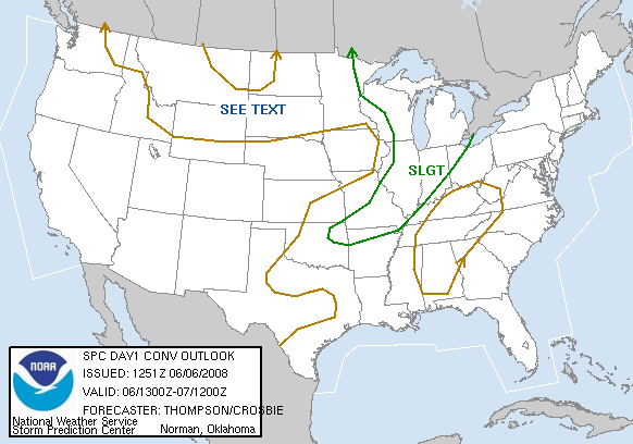
The morning SPC outlook maps looked like this: 1300Z 1300Z

  • 0930C – I check the models (my target for the day: Beatrice, NE area, about 2/3 of the way from Omaha, southeast toward the Nebraska-Kansas border). I like the Omaha option also because of the potential for Illinois and Iowa storms expected for the two days following, despite the long drive. Then grab a continental breakfast (‘con-brekkie’). My targets for the last two days were Wichita, KS (6/3: a bust, due to anvil blowoff killing the storm, as many folks witnessed) and south central Nebraska — between Beloit, KS and Hastings, NE (6/4: Per http://www.spc.noaa.gov/climo/reports/080604_rpts.html, a prolific tornado day there).
  • 1000C – Daily Briefing: We discuss two targets: south-central Nebraska (near my target) and the area where the dryline is expected (in mid/south Kansas). Storms will be fast-moving in either location, and we will be lucky to catch any storm long enough to get a good view of it. We will probably sit and let successive storms blow by us all day. *groan* Our strategy: start at the western edge of [cloud] clearing then slide east as storms move by us.
  • 1030C – Left Super 8 Motel at Hays, KS.
  • 1155C – Lunch. Depart Hays, KS east on I-70
  • 1228C – Scott checks storm to the southwest, but Sc obscures our view. We continue east on I-70.
  • 1231C – Cone zone! (Chasers hate delays and detours on storm days.) .We are at mile 203, but exit at 206 (KS232). We are under the anvil of a storm SW of great Bend.  Our storm look very elongated on GRlevel3 (base reflectivity on radar), due to upper level winds over 50 kts
  • 1237C – In Wilson, KS, heading west on old US40 (27th St.) then south.
  • 1201-1313C – (I need to revew times on the camcorder for the mssing entries here)
  • 1335C – We are passed by a fellow chaser sporting a lightbar with yellow flashers. Zoom!
  • 1341-1400C – (I need to revew times on the camcorder for the mssing entries here)
  • 1439C – East of Nickerson on US50, after another construction delay. (I see I’m not the only one using a hardhat for hail protection! Laughing)
  • 1519C – We depart Nickerson after about 15 minutes of shooting video and stils of the approaching storms.
  • 1740C – Leaving Newton, KS eastbound for _35 on KS96.
  • 2000C – Arrived at our motel and I’m online for the first time in several evenings

ESTIMATED TRAVEL

START TIME START ODOM. START LOC.
10:30C 67347 (T1 Chase Van) Hays, KS
FINISH TIME FINISH ODOM. FINISH LOC.
19:30C es. 67608 (T1 Chase Van) Wichita, KS
MILES TTL. ELAP. TIME REMARKS
9:00 est. 261 (T1 Chase Van) Haven’t we been here before?

DAY 12 – Chasing the Colorado High Plains – 20080604

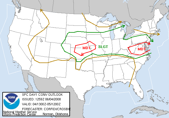
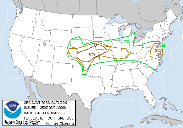
The morning SPC outlook maps looked like this:

CONVECTIVE OUTLOOK:

1300Z

TORNADO OUTLOOK:

1300Z

  • 0930C – Grab a continental breakfast (‘con-brekkie’). Learn that my hypothesis that WaKenney is the amalgam of two names is correct. Walter+Kenney=Wa-Keeney (yes, the early settlers apparently were spelling-challenged, but that was the least of their worries).
  • 1000C – Daily Briefing: Our target is northeast Colorado (again)
  • 1100C – Left Days Inn at WaKeeney, KS, moving toward Goodland, KS and the eastern plains of Colorado
  • 1123C – Moving east (!) on I-70
  • 1142C – On US183 at Hays, KS. we take lunch, then go west to Burlington, CO
  • 1715C – 2 miles west of Wray, CO, we double back into town, then move north, following a promising storm. It moves beyod our road network. Boo! (We snap some roadside photos of penny-sized hail, however).
  • 1724C – We return to Wray.
  • 1801C – We move west to Yuma, nearly missing the next storm due to construction narrow the highway to a single reversible lane. We turn south apause to take photos of foot-deep hail drifts, with hail nearing golfball size. We apparently just missed a spectacular hailstorm. We turn south, hoping to go east and catch this storm.
  • 1830C – We continue east through Vernon.
  • 1908C – After watching our storm from about 3 miles SE of Yuma, we return to Wray for a brief bathroom stop.
  • ____C – During our bathroom stop at the Wray 7-11 (translation: 20 people in a single file waiting to use the lone restroom), it starts to hail.  I get some video from inside the van, while others wait out the storm under the 7-11 roof. As hail reaches nickel size, we hear the tornado sirens go off, but see nothing. (Wray is in a bowl-shaped valley, so I’d be surprised if we had seen anything.)  After 2 minutes, then siren stops, as does the hail.
  • ____C – We move 3 miles east of Wray for photos of the back side of the hailstorm.  We are treated to brilliant gold and white clouds rising on the back of the storm anvil. with a prominent pileus cloud above. I shoot a 10-piece panoramic`shot (to glue together later).
  • ____C – Arrive at our motel for a night’s sleep

ESTIMATED TRAVEL

START TIME START ODOM. START LOC.
11:00 66754 (T1 Chase Van) WaKeeney, KS
FINISH TIME FINISH ODOM. FINISH LOC.
23:00 est 67347 (T1 Chase Van) Ogallala, NE
ELAP. TIME MILES TTL. REMARKS
12:00 est. 593 (per Faye) ______