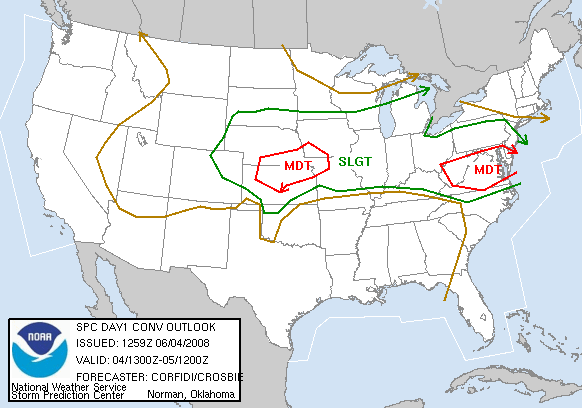
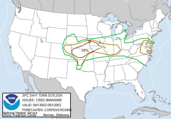
The morning SPC outlook maps looked like this:
CONVECTIVE OUTLOOK:
TORNADO OUTLOOK:
- 0930C – Grab a continental breakfast (‘con-brekkie’). Learn that my hypothesis that WaKenney is the amalgam of two names is correct. Walter+Kenney=Wa-Keeney (yes, the early settlers apparently were spelling-challenged, but that was the least of their worries).
- 1000C – Daily Briefing: Our target is northeast Colorado (again)
- 1100C – Left Days Inn at WaKeeney, KS, moving toward Goodland, KS and the eastern plains of Colorado
- 1123C – Moving east (!) on I-70
- 1142C – On US183 at Hays, KS. we take lunch, then go west to Burlington, CO
- 1715C – 2 miles west of Wray, CO, we double back into town, then move north, following a promising storm. It moves beyod our road network. Boo! (We snap some roadside photos of penny-sized hail, however).
- 1724C – We return to Wray.
- 1801C – We move west to Yuma, nearly missing the next storm due to construction narrow the highway to a single reversible lane. We turn south apause to take photos of foot-deep hail drifts, with hail nearing golfball size. We apparently just missed a spectacular hailstorm. We turn south, hoping to go east and catch this storm.
- 1830C – We continue east through Vernon.
- 1908C – After watching our storm from about 3 miles SE of Yuma, we return to Wray for a brief bathroom stop.
- ____C – During our bathroom stop at the Wray 7-11 (translation: 20 people in a single file waiting to use the lone restroom), it starts to hail. I get some video from inside the van, while others wait out the storm under the 7-11 roof. As hail reaches nickel size, we hear the tornado sirens go off, but see nothing. (Wray is in a bowl-shaped valley, so I’d be surprised if we had seen anything.) After 2 minutes, then siren stops, as does the hail.
- ____C – We move 3 miles east of Wray for photos of the back side of the hailstorm. We are treated to brilliant gold and white clouds rising on the back of the storm anvil. with a prominent pileus cloud above. I shoot a 10-piece panoramic`shot (to glue together later).
- ____C – Arrive at our motel for a night’s sleep
| START TIME | START ODOM. | START LOC. |
|---|---|---|
| 11:00 | 66754 (T1 Chase Van) | WaKeeney, KS |
| FINISH TIME | FINISH ODOM. | FINISH LOC. |
| 23:00 est | 67347 (T1 Chase Van) | Ogallala, NE |
| ELAP. TIME | MILES TTL. | REMARKS |
| 12:00 est. | 593 (per Faye) | ______ |