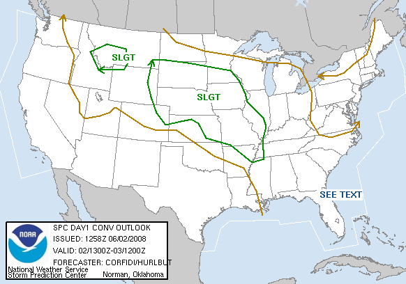
The morning SPC outlook maps looked like this:
- 0700C – Got about 6 hours sleep. Grabbed a light continental breakfast. Checked the models.
My target: NE panhandle, west of I-76/I-80 junction. - 1000C – Group met. we looked at surface obs, model data etc. as follows:
- RAP surface obs (wind, dew point, etc.)
Discussed wind convergence, location of front, storm genesis, rotating storms, and supercells - GOES visible satellite image for Nebraska (hi-res image, Weathertap)
- UCAR/RAP/ETA model
- 500mb winds — eastward trough to our west — supportive of storms; southwest inflow we like
- 700mb (10,000 feet MSL) — turning winds in NE Colorado
- 0000Z CAPE – Nebraska panhandle has CAPE bullseye (less CAPE needed, due to altitude)
- 0000Z Theta E (available moisture) – identified moisture axis runnng NW-SE north of NE panhandle
- 0000Z 12-hr precips – storm area in Nebraska panhandle, NE Colorado
- 0000Z Storm relative helicity (SRH)
- SPC Day 1 (D1) Outlook
- Target west edge of best risk in our chase range: NE Colorado, Nebraska panhandle
- D1 Wind Outlook
- D1 Hail Outlook
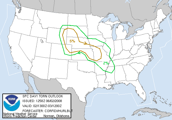
- D1 Tornado Outlook
- Glance D2 Outlook for planning/logistical purposes
- 700mb – -10 degC isotherm indicates where cap should hols storms for the afternoon
Cap too strong(-15 degC isotherm): no/weak storms, Cap too weak: unfocused, widespread storms, Ideal: explosive, focused storms - 500 mb winds – only good strength and direction on SE Kansas
- 700mb – -10 degC isotherm indicates where cap should hols storms for the afternoon
- D3 Outlook
- E Nebraska / W Iowa (start by Lincoln, NE?)
- 500 mb winds – only good strength and direction on SE Kansas
- D4-D6: A cahnce for severe weather
- RAP surface obs (wind, dew point, etc.)
- 1030C – Left Super 8 Motel at Colby, KS, moving toward far western KS and eastern Colorado.
- 1630C – Double back S from Wray, CO through Burlington, CO. 3-inch (baseball-size) hail seen scattered on lawns there, as well as sporadic street flooding. Full sun at Burlington. We blast east on I-70, following the storm that dropped the hail. We turn around about at Goodland, KS.
- 1840C – Returned to Burlington, CO after blasting east to Goodland, S following hailer. Storm fizzled.
- 1953C – North from Wray, CO (again) toward Julesburg, CO, I-76 and our next decision point. Storms develop just south of he NE panhandle.
- 2101C – Lv US6 for CO14 at Sterling, CO — moving west — stopped at N road to Kimball for lightning/sunset photos
| START TIME | START ODOM. | START LOC. |
|---|---|---|
| 10:30C | 17876 (TT4 Uplander) | Colby, KS |
| FINISH TIME | FINISH ODOM. | FINISH LOC. |
| 22:30C | 18311 (TT4 Uplander) | Ogallala, NE |
| ELAP. TIME | MILES TTL. | REMARKS |
| 8:01 est. | 435 miles | TT4 Uplander – finally, Scott gets a turn at driving |