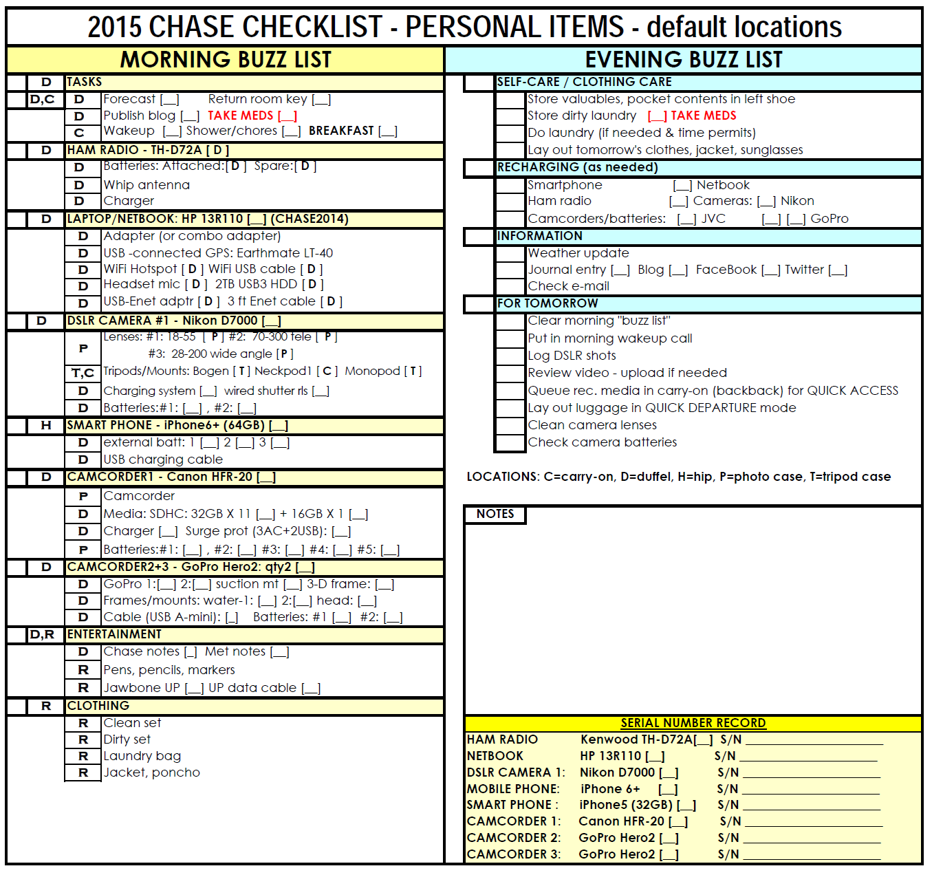
Every year my gadget collection evolves, as gear wears out or needs a technology refresh to keep up with new capabilities in the field. The following checklist (and its predecessors) have been my constant companion for over 10 years:
The ever-evolving checklist, obviously technology-driven (click to enlarge)
Without the list, I’d be rushing off on certain mornings, only to return to the motel where I’d left a key piece of gear.
I learned the lesson years ago when a member of the tour staff left an expensive camera in Norfolk, Nebraska. We returned several days later to collect the missing camera, but only after frantic phone calls and changes to our positioning strategy to allow the return. While the camera had been turned over to the local police department, it could have just have easily disappeared. After witnessing the anguish suffered by my chase companion, I decided not to repeat his experience. Thus, the list was born.
0600 – airport limo arrives. 1 passenger and four bags to O’Hare.
0644 – Arrive at O’Hare. My driver, Chip (short for Chiprian, a classic Romanian first name) helps me unload, runs my credit card ($56) for the fare, accepts my tip — I always try to do cash, because it is more helpful to drivers, as a rule — and I roll off to check two of my bags.
0700 – After a bit of fumbling and stumbling, my bags are checked in. I was so tired I almost left my boarding pass at the check-in kiosk! The upside: I got a TSA pre-pass. Not having to unpack my laptop, remove my shoes, etc. is really helpful in the pre-coffee hours of the morning.
0930 – we board the plane for OKC.
1015 – Tons of cumulus humilis are bubbling up to my west.
1115 – We lower to 5,000 feet, where we get a good look at the read clay soil of Oklahoma. The haze to the west clearly shows lot of moisture in the air.
1120 – Wheels down at Will Rogers Airport in OKC.
1200 – I arrive at the Holiday Inn as the local tornado sirens blare under blue skies. Is this a typical Saturday lunch signal, a personal welcome, or wild coincidence. I choose to take it as a good omen that our chase team will have a successful journey. I text Louise to alert her to her arrival; she replies that she’ll be down to the lobby in about ten minutes.
1210 – Louise Anderson and I meet for the first time. She is a quiet person with a bit of a Mona Lisa smile and a gentle demeanor. We chat for a moment. She’s had lunch already, but I’m famished. She decides to tag along while I grab a bite to eat at a nearby Subway sandwich shop to the west.
1254 – I grab a quick BLT footlong, thinking we will be going out toward El Reno to find the Twistex Team Memorial. When I mention that I also want to stop at a good camera shop Louise suggest we doubled back to the hotel so we can get her camera. I gladly agree, because it makes good sense to have your camera along with when you go shopping for accessories. We double back.
1320 (est.): We depart the hotel for El Reno, cameras in hand.
1350 (est.) – We exit I-40, southbound. We wander around just within a 2 mile radius of US 81 sticking mostly so the roads west of US81. We based our advice on a news article on channel 9, which as it turns out had east and west mixed up. We spent probably an hour wandering around looking for the memorial. We finally mosied up to a Days Inn and ask for directions.
1505 (est.) – We finally find the memorial, just east of the corner of Reuter and Radio Roads (approximately N35.479035, W97.898345).
Louise and I feel a strange mix of emotions. We’ve successfully found this treasure (despite a bit of misdirection from the Channel 9 video about the location being two miles west of US81, when it is east of that highway). We are also on the most hallowed ground of the storm chaser community.
Three of the most respected storm researchers to ever tail twisters lost their lives here. This location is somewhat desolate, with only the hum of tires from I-40 (a mile and a half to the north) to tie the place to civilization; it seems like an especially lonely place to die. Here, there are wreaths, flowers, a “pocket tornado” novelty, various chaser knick-knacks and some jagged pieces of automotive plastic that hint at the brutal pounding the chase team’s Chevy Cobalt must have endured. It is a very sobering reminder of how dangerous it is to chase storms. It is a tribute to the dedication of Tim Samaras, Paul Samaras, and Carl Young to better understanding of severe weather.
Team Twistex Memorial (approximately N35.479035, W97.898345)
1520 (est.) – We depart the Team Twistex Memorial.
1545 (approx.) – We arrive at Yukon. After a few minutes of wandering about, we visit Hank Baker at Baker Photo & Video. Hank runs a really well-equipped Canon/Nikon photo store (though he carries a few other brands). It has become my new Oklahoma home for photo equipment, to cover lost or damaged equipment, and hopefully some new gear someday soon. Hank always greeted us as if we were his long-lost friends or best neighbors, which is another good reason to shop there. Louise and I only picked up a couple of small items (lens cap keeper, UV filter, and various odds and ends). We may not spend as much money as some of his best customers, but he always treats us is if we were his #1 customers walking through the door. Such is the camaraderie amongst storm chasers.
1617 – We depart Yukon, re-entering eastbound I-40. While looking for the location of the Sam’s Club, I look down at the wrong moment. Suddenly the car is centered on an exit ramp for the Kirkpatrick Turnpike. Embarrassed, I ask Louise if she has 35 cents change. After the first convenience store stop of the tour, I’d already have an inconvenient supply of quarters and dimes, but it’s too soon. Fortunately, she has change. A quick Jordanesque dunk shot at the toll gate, and we’re off! We wander east on US66/OK66 (“The Mother Road”) and duck south on McArthur Boulevard to the Sam’s (which is a block south of I-40 on the frontage road). I wonder, “Do they have big box stores in Australia?”
1722 – We pick up some protein bars and a $13 tub of single use laundry soap packets to cover everybody’s laundry needs on the trip. I savor the 90-degree temperature, as it is so welcome to me after the brutal 2013-2014 winter in Chicago. “This Chicago winter was the 3rd snowiest and coldest winter on record,” I explain as we put our purchases in the car. We do a bit of mental math: this would be about a 32C temperature. Hot indeed!
1830 – Louise and I meet Owen in the lobby. After a few minutes, we arrive at Charleston’s a favorite American-style eatery just a few blocks south of the hotel. Owen orders a huge, inviting full rack of ribs, Louise choose a nice beef filet, and I opt for the prime ribs (medium rare, if you please!). We order an artichoke and chips appetizer plus the nacho/queso/salsa combination, not realizing what generous servings we’re getting. The appetizers arrive and we dig into them enthusiastically. Good eatin’! Once we start the tour, a sit down dinner will be a rarity, so we seize the moment. It is “the last supper” that most chasers embrace before a string of dinners at small town McDonald’s and gas station sandwich displays.
2026 – Depart Charleston’s. Man, am I stuffed! We carry several styrofoam — or polystyrene, if you’re British , like Owen — buckets of left over chips, queso and salsa. We head to a Super Walmart to pick up some provisions for the trip. Once we reach the tiny town motels along our journey, the last trace of big city luxury might be the travel size bottle of a favorite shampoo (versus the bland generic shampoo at the motel).
2119 – We depart WalMart. We arrive at the hotel, decide to gift the third shift desk clerk of nacho leftovers, and head off to our rooms for a good night’s sleep.
My feelings are amplified by the fact I gave up on chasing during this long weekend, but a MOD RISK has been issued. Had I followed my plan (on Friday) to travel west, go see Mt. Rushmore, then hope for storms, I could have been within reach of the expected storms:
OVERALL SEVERE STORM RISK
TORNADO RISK
Man, I need an attitude adjustment and fast!
And seeing the results of today’s storm isn’t making this easier:
Today will have to be a virtual chase day. My chase-cation is over and the weekend is behind me.
Hopefully, I’ll a) be available to chase next weekend and b) there will be severe storms with 500 miles of home during that time.
Gotta eat leaner when I not running around, toting bags of gear and clothing, etc. Virtual chasing gives me more choice, however.
Forecasting
Always another opinion
Just my own ideas and opinion.
I use the same technique: check the SLIM factors: shear, lift, instability, moisture.
I look at the SPC convective outlook maps and text for the day then try to identify what
they’re discussing on the NAM, WRF, RAP, HRRR models runs.I check the visible satellite pictures to see what sort of clearing and morning storms I have. I peruse logP-skewT charts around my target area to gauge what sort of moisture and wind setup I have.
I see where storm ingredients come together between 18Z (1pm CDT) and 0Z (7pm).
Since I’ve shadowed Bill Reid and seen so many of his forecasts since 2002, I try to do as Bill does.
(It’s served me very well, but I get too little storm time in the Great Plains to really boost my skills in the field.)
Computing / Comms Resources
My iPhone (RadarScope, MyWarn, etc.), my MSI Wind U120 netbook (1GB RAM, Windows XP, GRlevel3, GRLevel2Analyst, StormLab, Delorme Street Atlas, Davis WeatherLink), Sprint MiFi, connectivity prayers
All of the above, plus numerous 25-inch screens, quad-core desktop (Windows 7, 8GB RAM, all of the software on the netbook), 25Mbps internet, business-class high-redundancy router
More screen real estate and speed at home. My mobile gear has done well over the years, however. (Time to upgrade that 2009-vintage netbook next season, too.)
Watching the sky
Observe the sky directly. In the early Doswell days, the ability to read the maps was a beginning, but the ability to correctly read the sky often determined
Use fixed webcams across the web and (closer to storm time) streaming video from Spotter Network members to see what’s happening in the real world.
Obviously, the latter will introduce the bias of the person streaming the video, but I have a few favorite streamers to follow.
I feel we all have biases, so I try to choose mine carefully *smiles* .
Mo’ sky, mo’ bettah
Assumed base city: Wichita, KS (so I can join Jim, Jenna and Woodrow for the morning Starbucks run 🙂 ) Initial target: Comanche, OK
Basis:
(Verbiage to be added later. Short version: Looks to me like shear, lift, instability, and moisture all come together in south central OK around 20Z. Charts follow.)
Factor
Remarks
MAP 1 – 4-6pm
MAP 2 – around 7 pm
MAP 3 – after 7pm
_
_
_
_
_
_
_
_
_
_
_
_
_
_
_
_
_
_
_
_
_
_
_
_
_
_
_
_
_
_
1230 – A look st the SREF as I sit down to lunch (in both the virtual and real world) gives me pause for thought. It appears that Comanche, OK may be a bit to far southwest. In the virtual world, I’m at the Lawton Golden Corral (2632 Northwest Cache Road, Lawton, OK 73505) getting a good meal, as it looks like I won’t have a sit-down supper tonight. Suppertime is storm time, so I’ll be munching jerky then (albeit carefully, thanks to a temporary crown my dentist repaired on Saturday … in the real world.) Looks like I’ll need to relocate east then north; better keep lunch down to 15-20 minutes. Time to re-evaluate after lunch.
_
_
_
_
_
_
1250 – I slide east on OK7, then north on US81. Around 1330, ‘virtual me’ gives a wave to Jeff Piotrowski who’s eying the storm that’s gone up between Comanche and Lawton. (I’m always encouraged when I see somebody who really knows what they’re doing. It makes me feel a tiny bit more like I do, too.) Soon, the storm is shooting down some lightning and looking somewhat energetic.
Here are radar images of the storm, which produces a tornado later (though not as large or (thankfully) as deadly as the Moore, OK tornado of later today.
I am still trying to process the emotions of the day.
One person in the group has become so selfish, loud, vulgar, and arrogant that I have had waking fantasies of dragging him behind the van as we race into a hailstorm on a gravel road.
Another lost his wallet (and I feel terrible for him, especially because he is a talented and wonderful person).
I even feel a little down because my netbook is dead, one of my shoes is held together with duct tape.
And we did not see any severe storms, I feel disappointed that after tomorrow the tour is done. I fear having nothing to show for the money I spent.