- 0300 – Rise and shine
- 0330 – Off to the airport, thanks to help from my friend and neighbor, Stuart.
- 0400 – Change my 9pm flight to a 7 am flight. Now I’ll have time to explore Arlington, Dallas, and the rest of the civilized world of Texas.
- 0700 – Flight delayed 30 minutes, due to weather (How ironic!)
- 1000 – Arrive in Dallas. Grab my bags, get a rental car, go to the hotel.
- 1200 – Lunch at Mariano’s, home of the first frozen margarita machine. Its owner Mariano Martinez has been honored by the Smithsonian Museum for his invention, an adaptation of a common Slurpee machine into the mainstay margarita factory of restaurants across the nation. Mariano is credited with doing more to sell tequila-based drinks than anyone else on the planet.
- 1430 – Check in. Take a nap
- 1800– Wake up. I apparently have been battling acid reflux (a by-product of pigging out at Mariano’s). I feel like my meal returned to visit the back of my throat for several hours as I napped. No wonder all those painting of guys taking a siesta show them leaning against a building versus laying down. Oy! Lesson learned!Also, it looks like the others have not arrived yet (or are not interested in getting together for dinner). Such is life!
- 2145 – After venturing out to Fry’s Electronics and a visit to the Sonic drive-in (for a banana milk shake to soothe the savage stomach). I’m turning in for the night. I’m not very optimistic about our chances for sever weather for the next view days. I wonder how we’ll pass the time.
Category: Chase Day
Chase Day
29 May 2011 – Fast Movers!
Chased after some fast moving storms, but could not circumnavigate the south Chicago metro area and keep up at the same time. These storms produced tornadoes around Kalamazoo, MI, but I was 2 hours away as this happened. At least I got a good look at some dramatic daytime anvil crawlers. Sorry, no photos. But the GoPro camera is on my Christmas list. After seeing Chris Gullikson use it so effectively, I want one! I may even go 3D (http://gopro.com/hd-hero-accessories/3d-hero-system/).
The good news is that I passed my Spotter Network exam and have the software for real-time reports set up. The near real-time positioning works as long as I have a broadband connection up (and the laptop does not hibernate, as it did when I stopped for a quick McDonald’s run).
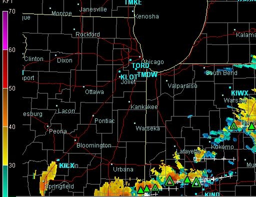
Was I wasting my time? Maybe. Was it a good storm day? Yup. Check this storm reports excerpt:
000
NWUS53 KLOT 292344
LSRLOT

PRELIMINARY LOCAL STORM REPORT...SUMMARY
NATIONAL WEATHER SERVICE CHICAGO/ROMEOVILLE IL
644 PM CDT SUN MAY 29 2011

..TIME...   ...EVENT...      ...CITY LOCATION...     ...LAT.LON...
..DATE...   ....MAG....      ..COUNTY LOCATION..ST.. ...SOURCE....
            ..REMARKS..

1145 AM     TSTM WND GST     DUPAGE AIRPORT          41.92N 88.25W
05/29/2011  M58.00 MPH       DUPAGE             IL   ASOS
            1135 CDT.

1224 PM     HAIL             KINSMAN                 41.19N 88.57W
05/29/2011  M1.00 INCH       GRUNDY             IL   AMATEUR RADIO
            WEST OF THE TOWN ON GARDNER ROAD.

1253 PM     HAIL             JOLIET                  41.53N 88.12W
05/29/2011  E0.25 INCH       WILL               IL   TRAINED SPOTTER
            INTERSECTION OF ROUTE 30 AND GOUGAR ROAD.

1259 PM     HAIL             NEW LENOX               41.52N 87.98W
05/29/2011  E0.75 INCH       WILL               IL   TRAINED SPOTTER

0103 PM     FUNNEL CLOUD     KANKAKEE                41.12N 87.86W
05/29/2011                   KANKAKEE           IL   TRAINED SPOTTER
            CROSSING I-57

0105 PM     TSTM WND DMG     KANKAKEE                41.12N 87.86W
05/29/2011                   KANKAKEE           IL   LAW ENFORCEMENT
            12 TO 16 INCH DIAMETER TREE UPROOTED ON COBB ST. TREE
            FELL ON CAR. DRIVER NOT INJURED.

0105 PM     FUNNEL CLOUD     HERSCHER                41.05N 88.10W
05/29/2011                   KANKAKEE           IL   TRAINED SPOTTER
            AT COUNTY LINE RD 8000 S AND RT 45.

0105 PM     TSTM WND DMG     KANKAKEE                41.12N 87.86W
05/29/2011                   KANKAKEE           IL   LAW ENFORCEMENT
            TREES DOWN ON CAR ON COBB BLVD

0115 PM     TSTM WND DMG     KANKAKEE                41.12N 87.86W
05/29/2011                   KANKAKEE           IL   TRAINED SPOTTER
            3 LARGE TREES DOWN ON MAIN ST NEAR HOSPITAL

0115 PM     TSTM WND DMG     KANKAKEE                41.12N 87.86W
05/29/2011                   KANKAKEE           IL   LAW ENFORCEMENT
            TREE LIMBS AND POWER LINES DOWN CITY WIDE
|
I am also running with the $25/month AllisonHouse data service subscription. It’s WAY easier to make chase decisions when you can see fronts quickly (like the warm front below), take the tornado risk ‘blob(s)’ — the purplish contours, below — into account, see dew point contours (green), etc.:

NOTE: This particular screen shot shows why Tempest Tour’s Bill Reid chose to stay at West Point, NE (near KOAX) last night: short drive, big storms right on the doorstep. His passengers even have time for a Walmart run this morning and a sit-down lunch before scoring a big storm. Good call, Bill!
24 May 2011 – Interim report
Here’s a quick snapshot from my chase log book (not yet reconciled with timestamps on photos, video, etc.), Click on any image to see a pair of pages in their entirety, using the YYYYMMDD date at the top of each page to determine when I wrote these:
More coming soon!
22 May 2011 – Southwest City, MO tornado (near Joplin)
Best video of this trip: Southwest City, MO tornado – 22 May 2011 (on YouTube)
22May2011 – DRAFT


17 May 2011- Meanwhile, 300 miles away…
17 May 2011 – DRAFT
|
|
|


(more TBD)
Our route for the day took us from Childress, Texas, across the Oklahoma panhandle, to southwest Kansas, ending at Liberal, Kansas:

Even though we didn’t see storms, the Weather Channel crew documents the day. Here, Jim Cantore interviews Williaam Reid, our tour leader, about the events of day:

On the whole, the day was disappointing, as storms near Fort Morgan, Colorado did produce tornadoes. These were too far from us for us to reach. Until chase forecasts include the ability to foresee the future, the 2-target chase day will be a coin toss.
(more TBD)


- Chase Logbook pp 20110516-02,20110517-01
Pre-4th Fireworks
After church and a lunch with friends, I took off south from Chicago for the I-70 corridor. The RUC model showed a prominent band of CAPE for that area, so I targeted I-70 just west of Indianapolis, thinking I would drive westward into the storms and get a good lightning show and maybe some quarter-sized hail.
Some of the storms (as this cloud tops image shows) were fairly developed in the vertical:
http://underthethunder.org/live/images/radar/20100627_kind_et_8a.jpg
No hail seen, but plenty of pretty lightning and a smidgen of video captured. Mission (albeit it a small one) accomplished.