To quote the DAY 1 SPC convective outlook:
...IA/NW IL AND VICINITY...
   WEAK ELEVATED CONVECTION NOW OVER IA/NE NEB SHOULD CONTINUE
   GENERALLY NE INTO THE UPR MS VLY TODAY AS LEAD PORTION OF CNTRL HI
   PLNS IMPULSE CONTINUES NEWD.  CONVECTION ON THE SRN FRINGE OF THIS
   ACTIVITY MAY BECOME SFC-BASED AND DEVELOP MORE E OR ESE INTO PARTS
   OF IL/IND AS SFC HEATING DESTABILIZES AXIS OF MODEST LOW LVL WAA ON
   NRN FRINGE OF UPR RIDGE.  WHILE AMPLE INSTABILITY WILL EXIST FOR
   STRONG/POSSIBLY LOCALLY SVR STORMS...MODEST SHEAR SHOULD LIMIT
   OVERALL SVR THREAT.

   IN WAKE OF MORNING ACTIVITY...SFC HEATING AND UVV ASSOCIATED WITH
   MAIN LOBE OF HI PLNS DISTURBANCE SHOULD FOSTER SFC-BASED STORM
   DEVELOPMENT ACROSS IA/SRN MN AND PERHAPS NW MO BY EARLY AFTN...ALONG
   AND SW OF WEAK WARM FRONT.  MID LVL LAPSE RATES WILL REMAIN
   COMPARATIVELY WEAK.  BUT COMBINATION OF RICH MOISTURE /PW UP TO 2
   INCHES/...MODERATE DESTABILIZATION...AND 30 KT DEEP WLY SHEAR WILL
   SUPPORT SUSTAINED STORMS/SUPERCELLS WITH DMGG WIND AND POSSIBLY
   HAIL.  MORE SIGNIFICANTLY...BACKED/SELY LOW-LVL FLOW AND LOW LCLS
   NEAR WARM FRONT WILL BE FAVORABLE FOR TORNADOES...ESPECIALLY OVER
   NRN/ERN IA AND ADJACENT PARTS OF IL LATER THIS AFTN AND EVE.

   FARTHER SW...BOTH SHEAR AND INSTABILITY SHOULD DIMINISH WITH SW
   EXTENT INTO NRN/ERN KS...WHERE SVR WEATHER LIKELY WILL BE MORE
   LIMITED.
 Based on ETA models, I am targeting a late afternoon (4-7pm) target of Waterloo, IA. I can depart immediately after church, arriving around 4:30pm in the target zone, returning via I-380/80/55 or via US20/I-90/I-355.
- 1217 – dpt Romeoville,IL for IA via I-80. Rain and construction slow traffic to 55mph for 50% of Lasalle-Moline stretch.
- ____ – enter IA via I-280 (as I-80 Miss R bridge is closed)
- 1500ax – stop at I-80 Truck Stop (Walcott, IA). Signs all around say “The World’s Largest Truckstop” and I believe it. THIS PLACE IS HUGE! I make a quick washroom/snack break. Upon returning to the van, I consulted Mesoscale Discussion 1259 after my ham radio’s APRS display indicated the MD was active. Looks like the area I picked will have warnings. Time to get moving!
- 1703 – I pull off the road to grab a quick bite to eat. I spot a Sonic drive-in and give in to my love for their famed cherry limeade. As my order arrives, a tornado warning goes up 70 miles to my west. Time to eat and run. [I also should have fueled up the van. Read on!]
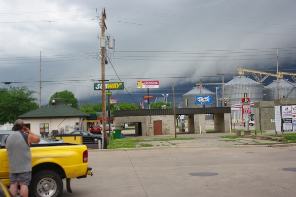
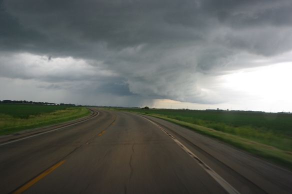
- 1830 – I roll west on US20 to Buckeye, where I spot two storms with interesting lowerings that might soon be (or recently have been) wall clouds. I sit and watch until a dark precip core approaches. I run west a few miles, catching only a few minutes of moderate rain on the NE side of the core. I let it pass, as radar shows several storms lined up.
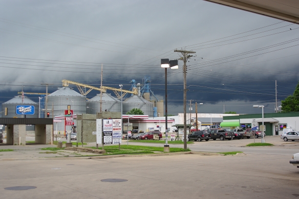
- 1854 – I double back east and spot a growing chaser convergence (always a hopeful sign)! I stop briefly to watch the storm and see a well-defined clear slot to the ENE. Moving a few miles east (to the Steamboat Rock, IA exit), the sky shows a classic pre-tornado setup: rain-free base, an incipient RFD to the northwest (evidenced by dusty inflow), a sharply defined clear slot, and increasing rotation just east of the clear slot.
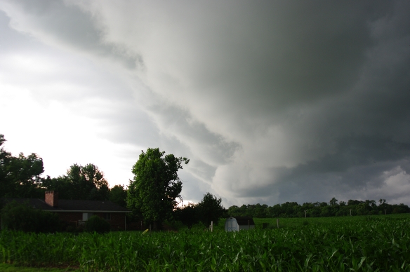
- 1859 – Tornado! It only lasts 30 seconds (and the view is partly obscured by trees), but I get it on video. This moment is a tiny personal milestone: my first tornado on an unassisted solo chase: no nowcast buddy, no partner … all my decisions, for better or worse. The storm still shows plenty of signs it could produce another tornado, so I move 5 miles east for another look.
- 1910 – Oh my GOD! I look at the fuel gauge and see it reads 1/8 tank. I move further east on US20 to Dike, IA in hopes their gas station is open, has power, etc. Fortunately, it is, so i quickly fill the tank. As the pump clicks off at the end of the fill, the tornado sirens sound! Crap! I grab my receipt, get back in van, start it up, start the cameras and charge back through town, looking 360-degrees around to make sure a tornado has not dropped nearby. The folks in these little towns are very self-sufficient and see lots of storms, so this is almost certainly not a false alarm. As i return to US20, I see a wide conical lowering about 1/2 a mile south of the highway, but it shows no rotation. [ed. – The next day, I check the storm reports: the very real tornado (at 0048Z) had damaged a house 5 miles NW of Dike … definitely good cause to sound the alarm.]
- 1955 – With a full tank and the daylight running out, I decide to head home. On the east of Waterloo, I miss the turn for I-380 and end up on US20. I detour to SR150 south, to re-acquire I-380. Along the way I get a real good look at the storms with tornado reports west of I-380 and south of I-80 (by Kolona and Marengo). The supercell directly to my south is tall, has hard-nosed features, a health anvil, and (II think) an overshooting top (though lower clouds partially obscure my view of that top). Now is the time to get ahead of these storms and get back to Illinois.
- 2100 – I cross the Mississippi, back into Illinois. My fleeting glance of the river is breathtaking: the reds, oranges, pinks, and purples of the fading sunlight turn the water into a vibrant splash of color.
- 0030 – I return home and go to bed, satisfied with the day. though very tired.
ROUTE: 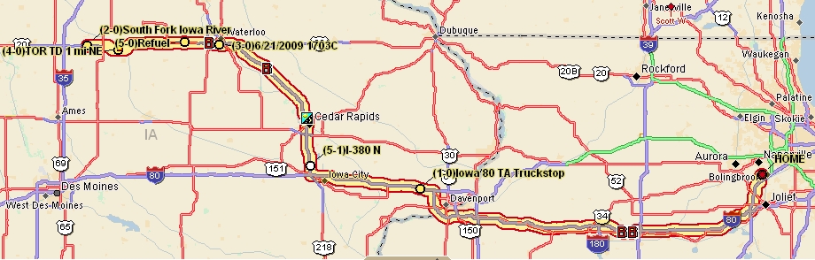
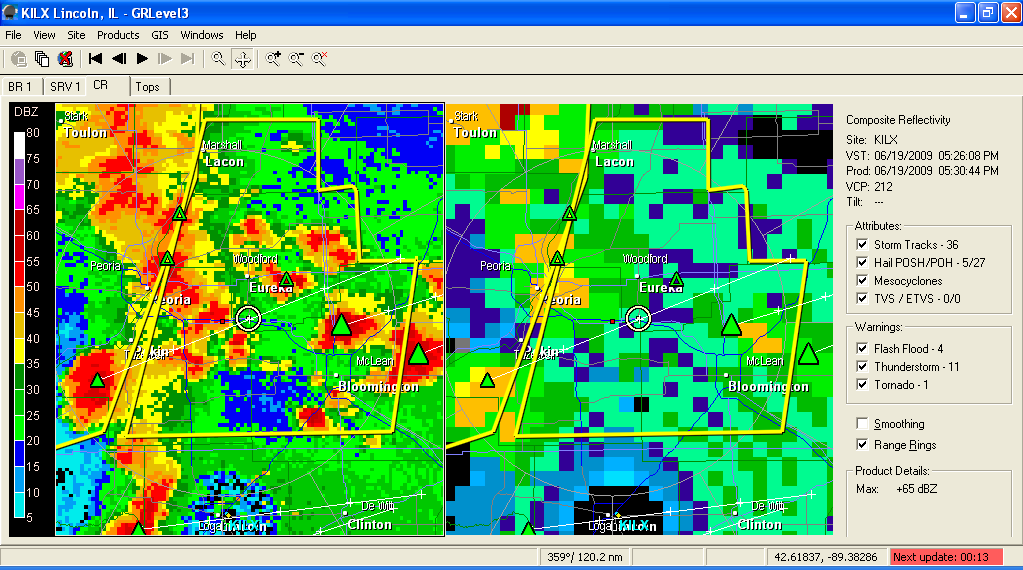
 0814 – Fuel up van, grab a sandwich at Morris (R Place) – random encounter w/Mike, a former Red Lobster mgr at Bolingbrook – decide to detour toward Rockford/Freeport on I-39, based on radar of strong storm. I hope to see some strong winds in action, perhaps catch a bit of hail, and get video of the storm in action. Little chance these morning storms will produce a tornado. A storm over the Chicago suburb of Algonquin, IL gets tornado-warned, based on radar, for a brief while about this same time.
 I traverse N side of Rockford to I-39/I-90 southbound.


 Radar shows storms heading my way, so I hang out in the area. This time, I verify that the weather radio agrees with the radar (to avoid the mistake I made with morning storms).


 West of Peoria, I opt for westbound US24, hoping to reach storms approaching from Missouri. The storms between I-57 and I-65 (in Indiana) look better than what I see ahead, but they are out of reach at this point. North of Havana, I take some pictures of the marshes near the Spoon-Illinois River confluence: